Saturday, July 31, 2010

Mt. Democrat, Mt. Lincoln, Mt. Cameron, Mt. Bross (7/31/2010)

Route Name: Northeast Ridge from Stewart Creek (standard route)
Start Elevation: 12,000 ft.
Mt. Democrat Elevation: 14,148 ft.
Mt. Cameron Elevation: 14,238 ft.
Mt. Lincoln Elevation: 14,286 ft.
Mt. Bross Elevation: 14,172 ft.
Elevation Gain: 3,524 ft.
Round-trip Mileage: 6.92 mi (according to my GPS, 7.25 mi. according to the books)

Introduction

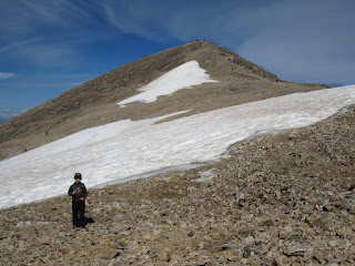
Before this hike, I had done 36 of the 54 14ers. I finally decided it was time to deal with the crowds of the DeCaLiBro. My father did these back in 1990 and its amazing to see how "popular" hiking the 14ers has become. I can recall doing Quandary as my first back in 1991 and only running into a few select parties that day. How times have changed.
The other highlight of today is we decided that Democrat would be a good first 14er for my five-year old son Luke. The distance is quite short and the "class 2" of the hike from the Democrat-Cameron saddle is quite modest.
Luke did quite well. While I and my friend Matt hiked ahead and went for the loop hike from Kite Lake my son Luke hiked with my parents at a slower pace. Keeping things slower and interesting for my boy he was able to summit Democrat with little trouble. The big positive from the crowds is Luke had plenty of encouragement from very nice people along the way. He turned out to be the youngest on the trail that day so he had some celebrity going with this. The other motivation for him was the word of a large snowfield just below Democrat's summit. And he did indeed enjoy a great snowball fight after summiting.

From the summit of Mt. Democrat
From the summit of Mt. Lincoln

From the slopes of Mt. Bross

Words of wisdom from this experience of taking my 5-year old up a 14er:
  1. Be prepared for all potential 14er hazards. He was equipped with raingear and good weather report for the day. He was equipped with a small REI kids pack with its own camelbak and we forced him to hydrate regularly to ward off dehydration and altitude sickness. He was equipped with proper hiking shoes and clothing overall. In other words, taking your young kids on a 14er is no child's play.
  2. Keep him motivated. Somehow it seems 5 years don't quite have the same appreciation of nature and climbing and the outdoors as adults do. They're mostly out there because its what Dad does and "monkey see, monkey do." Give the kid goals to shoot for and keep his/her mind off of how long or hard the hike seems.
  3. Allot for lots of time. Kids love to explore every stick and rock along the way and need the time to rest and enjoy the hike. This speaks especially to making sure the weather is allowing the necessary time for the hike.

Words regarding Bross
It is very clear from signage that the summit of Mt. Bross remains closed. For those wishing to hike all three official 14ers in this loop here is what we learned during this hike:
  1. As we stood on Lincoln's summit we could see a pickup truck and a man in the distance parked on the summit. On this particular Saturday they were up there from roughly 9:30am to 10:30am. As we traversed Cameron we saw the pickup truck leave the summit and shortly thereafter several hikers heading up to the summit.
  2. As we hit the descent trail on Bross, around 11:10am, we heard a pair of motorbikes and at least one ATV roaring up to the summit of Bross. Somewhat humorously, the summit of Bross soon looked like a herd of cockroaches when the light is turned on as a swarm of roughly 20 hikers went full-speed down the western slopes from Bross' summit heading for the descent trail. Not sure what the owners do to those found on the summit. But IMHO, if you do decide to summit Bross, might wish to at least be somewhat respectful and make your stay clean and short.

WEATHER

Had a perfect day for weather. Though most of our trip out to Colorado had the daily 60% chance of thunderstorms forecasted, we were fortunate enough never to get any morning rain. This day saw no issues with impending storms. The clouds that did roll through just added to the great panorama of photos we took.

CROWDS/PEOPLE

Wow. This by far was the most people I've ever seen. It was a good weathered-July Saturday and literally everyone and their grandma was up there (we did see someone in their 70s!). My estimate is 250+ people. The route up Democrat was like a trail of ants. As we moved on to Cameron/Lincoln the route still had a lot of people but was *much* less crowded.

TRAIL BETA

Little to add here. The entire route is easy to follow. The signage near Bross is easy to understand and follow. We did run into a very kind CFI crew on the descent from Bross whom we talked to for awhile. They were on the lower 20% of the trail working on re-routing the trail through rock steps to make it more self-preserving as opposed to going up through the dirt/grass slopes.

TIME

Up Democrat in 1:32:34
Over to Cameron in 1:12:42
Over to Lincoln in 14:57
Over to and down Bross in 1:59:49

TRACK

Here is the track file from our climb:

My Track


PHOTOS

If you wish to see all of my photos from this hike you can click the photo below and it will link to my Google Photo Album:

Friday, July 30, 2010

Frisco, Breck, Vail Pass Bike Loop (7/30/10)

Stopped along the path just southeast of Frisco,
looking to the north
This hike was planned on a whim. Somewhere in the midst of our conversation we got talking about biking and getting outside for some fun. Matt H. quickly did some Google-ing and found that Rebel Sports in Frisco had good bike rentals. He and I were quickly walking down the road to rent some bikes for the day. About 10am we got down there and for $15 for 2 hours plus another $2/hour past that we were off. We hopped the trail in Frisco and headed for Breckenridge. There was a brief climb and then a downhill in the forest heading south out of Frisco. The rest was a gradual climb down to Breckenridge. This took us nearly an hour to reach Breckenridge where we stopped near downtown and the first gondola ride.

Stopped along the path just northeast of Frisco,
looking to the west
We turned around after a snack and enjoyed the now gradual down-slope back to Frisco. We cruised on this part and stopped just once for a picture. The up-climb back into the forest near Frisco was a challenge. We made it back by noon for lunch at the condo. We inquired at Rebel Sports about their "free" shuttle up to Vail Pass but that was only valid for people paying the daily rate. We decided to hitch a ride in one of the minivans for Vail Pass in the afternoon.

The Vail Pass idea was enough to get Denny (Dad) on a bike. He quickly went down to the shop and rented a bike of his own. We found Sarah to be kind enough to drive us and so we loaded three bikes into a minivan and were off to Vail Pass. With me as driver I messed up and missed the exit for Vail Pass which meant driving another 7 miles on to Vail itself, u-turn, and then back to Vail Pass.

Stopped along the path just northeast of Frisco,
looking to the South
Matt, Dad, and I began the great descent from Vail Pass. This was a blast as we were able to cruise almost the entire way down to Copper Mountain, riding the brakes through several portions. We only had to actually pedal 2 or 3 short times to get to Copper. In Copper we had to slow down considerably as the bike trails wound through the small town. The rains started on us as we hit the east side of Copper. We stopped under a gas station canopy to stow our electronics in our backpacks and then hit the trail again. The rain was just light enough it didn't kill our traction on the bikes, but we did have mostly sprinkles the rest of the way to Frisco. We arrived back at the condo around 3pm and we returned the bikes.

STATS

Distance: 32 miles
Time on the Bikes: 2 hours, 30 minutes

TRACK

I have here a KML file which combines the tracks from all 3 legs of our biking.

My Track


Thursday, July 29, 2010

Mt. Harvard, Mt. Columbia (7/29/10)

Route Name: Harvard South Slope with traverse to Columbia's North Slope and descent on Columbia's West Slope
Start Elevation: 9,900 ft.
Mt. Harvard Elevation: 14,420 ft.
Mt. Columbia Elevation: 14,073 ft.
Elevation Gain: 5793 ft.
Round-trip Mileage: 14.7 mi (according to my GPS)

Introduction

Spent a lot of time reading routes and TR's for the Harvard and Columbia combo, so we were pretty sure we knew what to expect. We set out for the TH at 3pm from Frisco, it was my friend Matt and I, plus my father and 5-year old son. We grabbed some Subway in Leadville and ate it at the trailhead. We spent about an hour and a half hiking in 2 miles or so to about 11000 feet and found a nice established campsite just off to the left (south) of the trail. Had a nice fire that night despite the wet ground conditions.

Wednesday, July 28, 2010

Mt. Royal (7/28/10)

Route Name: Mt. Royal trail (standard route)
Start Elevation: 9,120 ft.
Summit Elevation: 10,480 ft.
Elevation Gain: 1,360 ft.
Round-trip Mileage: 4.8 mi (according to my GPS)

INTRODUCTION

We got up by 7am to begin the hike up Mt. Royal. We found a good path back to the bike trail and then onto the Royal Trailhead. We left around 7:30am up the mountain. This morning's hike included Luke, Jonah, Mark, Marcia and Denny. No Seth this time. We moved at a fair pace keeping the boys interested in the hike. Jonah ended up being carried by Mark for a good 2/3 of the climb up Royal. Luke did well enough to walk the entire way. The boys took turns carrying their new REI kids backpack and drinking out of the hydration pack.
We summitted around 9:15am and Mark continued on hiking east along Royal's ridge to another rock outcropping with a good view of Frisco. As Mark did that the others spotted a fox on the trail who came up pretty close. We were atop Royal for a good 30 minutes before heading down. Jonah did much better on the way down. Mark carried him on his shoulders down through the steepest portion of the trail and Jonah then walked the rest of the way down.
We were back to the Condo by 11:30am.

TRACK

Here is the track file from our climb:

My Track


PHOTOS

If you would like to see all my photos from this hike you can click the photo below and it links to my Google Photo Album:


Friday, July 2, 2010

Wisconsin Century Ride (7/2/10)

This was my second "Century Ride" up the various bike trails in Illinois to the Wisconsin border. This day I was joined by Denny (Dad) as well as Matt H. This would be Matt's first century ride and the 4th or 5th at least for Denny. Weather report was perfect for the day and indeed the weather was great and sunny all day.

We left on the Great Western Trail from Lombard just after 6am. We took this west and it eventually hooks up to the Elgin Branch of the Illinois Prairie Path. As the IPP begins to turn north and hits Elgin it eventually turns into the Fox River Trail. This continues north along the river and eventually turns into the Prairie Trail around McHenry. From there it heads north to the Wisconsin border where it ends at Genoa City. We made great time and were feeling good the whole hike north. It was fun heading through Stern Woods again around Crystal Lake where the big hills provide a challenge to the gears (and the legs!).

We made the Wisconsin border at 11:20am. We spent 10-15 minutes making phone calls, posting on twitter, and catching a drink. We were getting pretty hungry, despite the light snacking. We had originally considered hitting the Subway near the northern end of these trails. But we then decided loading up on a big sub wouldn't do well for the tummy. We hit a gas station instead and loaded up on slim jim-style meat and other lighter snacks for lunch. The ride back was a joy as well. The length of the day and the exhaustion of the legs didn't really start to sink in til we were getting onto the Great Western Trail once more. Actually for me the worst part of the return was the sore hind end from sitting on a tough bike seat all day. I nearly wanted to stand on my pedals and not sit the entire trek back on the Western Trail. We hit Lombard at 5:36pm and were most happy to be able to get off those bikes. We treated ourselves to an awesome supper at Buona Beef. Yum!

STATS

Distance Total: 118 miles
Total Time: 11 1/2 hours

TRACK

Here is the KML track file for our bike hike:

My Track

Popular Posts