I'm learning to become old acquaintances with challenges and failure. I chose to tackle a big self-made adventure again this year with high aspirations, but it didn't quite go as planned. I've been doing ultras for several years now and I decided my big goal for summer 2023 was what I would call an "adventure ultra", that is, not a sanctioned race but rather an ultra length adventure of my own making. I wanted to create my own route and then see if I could complete it. Half the adventure would simply be in the weeks and months of planning for this adventure and that part went exactly to plan.
While my big ultra adventure didn't go exactly as planned its hard to say that it was a total failure. I fell short of my ultimate goals but I still accomplished a lot and I didn't quit in big ways where I easily could have. Perhaps most importantly, I had a great time and still put a wonderful challenge to myself and felt very good about it in the end.
Trip Info:
Hiked the North Cottonwood Road from the Harvard Lakes Trailhead to the North Cottonwood Trailhead. Then hiked the standard route to the summit of Mt. Columbia. Then the traverse route over to Mt. Harvard. Descended off the north side of Harvard and bushwhacked a route off its north ridge heading to the west and northwest towards a crossing of Pine Creek. Then hiked the Pine Creek Trail out to its junction with the Colorado Trail. Then hiked the CT back to Harvard Lakes Trailhead.
Trailhead Elevation: 9,416 ft.
Mt. Columbia Elevation: 14,075 ft.
Mt. Harvard Elevation: 14,424 ft.
Distance: 31.14 mi.
Elevation Gain: 9,936 ft.
Start Time: 5:42am
End Time: 7:48pm
Trip Report:
The route I eventually chose was not my initial choice. In the several months leading up to my June date I actually changed my route up several times. My initial inspiration for this hike was a somewhat simpler goal. I have looked at the possibility for several years now of hiking from the Pine Creek TH up to its junction with the Colorado Trail. I would then take the CT up to Oxford's south ridge and follow it to the summit and then on to Belford. I would then descend to Elkhead Pass and on down to the Pine Creek Trail, and then head back out to the start. This by itself would be a great day's adventure which I pegged to be in the low 20s for mileage. I had done a similar style adventure in July 2021 when I did my Yale Silver Creek Loop. Starting and ending at the Silver Creek TH I ascended Yale's East Ridge, then descended and hiked around to Brown's Pass, then down past Kroenke Lake and back out the North Cottonwood Road to my start. I loved the idea again of a large mountain loop starting and finishing in the same spot.
 |
| Mt. Yale from Columbia's west slopes |
As I weighed the challenge of a 2023 adventure I started with my loop idea of Oxford and Belford and then decided Missouri wouldn't be too crazy an add-on. Just a couple more miles and some more elevation. Then things escalated and I decided that it was also within the realm of possibility to consider a Harvard and Columbia add-on. This was where the mileage began to dive into ultra territory appearing to be in the mid 30s for miles. It had me excited. Imagine trying to hike up five 14ers all from a single trailhead at Pine Creek. I was hooked on the idea.
That was true until I had another idea. What if I tried all five of the 14ers from the Harvard Lakes Trailhead. I liked this idea more for a couple reasons. For starters this trailhead is closer to where I was staying. It was a short simple drive in the morning. I also like the idea of doing Columbia and Harvard first and getting the more difficult tasks out of the way on fresh legs. Hiking the remaining miles on the CT to end the day sounded like a smart idea. So this was ultimately how I settled on my course.
In the midst of planning I also began to weigh all the possible contingencies to my route. If things went wrong there were plenty of options. I could always bail out on the Pine Creek trail. I could also skip peaks like Missouri if it became necessary due to weather or other circumstances.
TRAINING
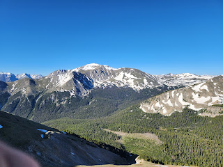
 |
| Harvard from Columbia's summit |
During summer 2021 and 2022 I worked through a big 50-mile ultra training plan following a daily regiment with weekly mileage peaks nearing 70 miles. In 2023 I was trying a much more casual plan. This was partly due to more demands at home and our 18-month old taking up all of my waking hours at home.
My training plan this summer was almost entirely driven by my Garmin Fenix 7 watch. Back in March and April I had used its daily suggested runs while training for a trail half marathon and I set a trail PR in the race. So I kept going with the Garmin suggestions while training for this ultra adventure. I added in my own customizations especially with long runs along the way. In late May I worked in a training marathon just to push the distance.
The other aspect to my training was pushing a lot of climbing training. I was working to get 5000 feet of gain every week. This isn't easy living in Michigan. I accomplished this with a mix of floor climbing and treadmill work. Occasionally I was fortunate to do it out in the wild on actual trails. The one thing I missed out on was doing strength training along the way.
GEAR / HYDRATION / NUTRITION
I wanted to make this ultra adventure a mix of running and hiking. Lately I've been enjoying using my Ultimate Direction Ultra Vest 5.0. I used it on my Yale Silver Creek Loop and it really gets the job done. Given the greater length of this 2023 adventure I did not believe the basic vest could hold all the food and gear I would want. I was lucky to find an Ultimate Direction Fastpack20 on sale and I decided to go with the bigger vest. I had also considered my regular daypack but I wanted to stay with the vest style with hopes of having my pack ride better for some trail running.
 |
| Large snow patch low on Columbia's approach |
I also carried my trekking poles, a light jacket, all my food for the day, water filter, and other small basics. Food-wise I was targeting between 250-300 calories an hour. Some of the calories I would drink using a mix of Tailwind and Gnarly powders. The food was a heavy carry but I hoped with the full calorie load I could keep the effort going in the more difficult moments.
I had plans to not carry more than 1.5 liters at any given time and in many places just one liter. I had noted on my GPS map all the places I thought I could filter and refill and the plan was to keep the load light by never carrying more water than needed. The difficult carry would be the long haul over Columbia and Harvard which had no notable water fill spots after starting up Columbia. In the end I would filter in five different places going through something like 7 liters for the effort. My Katadyn BeFree was the real hero of the day making filtering so easy and quick.
TRIP REPORT
The beginning of the day went as planned. I got started right around sunrise and hit the road from the Harvard Lakes trailhead at 5:40am. I had made some time benchmarks in my plan to have an idea of where I should be throughout the day and mark my progress. I was hoping to complete the entire loop in 15 1/2 hours. I had measured the loop to be 35.6 miles and around 11,000 feet ascent.
On the road I lightly ran some of the flats to test out the legs for the day but I never pushed any sort of pace. I made the North Cottonwood trail in 27 minutes which was 3 minutes ahead of schedule.
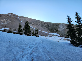
 |
| Snow on the Hork Forn Basin trail |
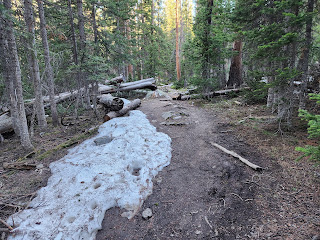
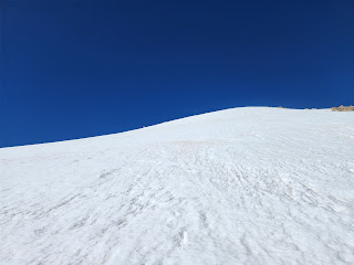
On the North Cottonwood trail I lightly ran a few more of the flats while the trail was by the river but as it began to climb more into Horn Fork Basin I kept a steady hiking pace. I was a little surprised early on how regularly my heart rate was already in the 120s and 130s. Maybe I was pushing the pace too hard. Maybe I was finding out early, this might just not be my day. As I began to near the junction where the Columbia trail breaks off I began to encounter snow banks on the trail. They slowed up progress a bit. The melting also created a number of muddy spots along trail and I ended up getting my shoes wet in a few places. At what I thought was one of the last small creeks near trail before Columbia, I made my first water filter of the day to be able to carry my full 1.5 liters of water for the 2 peaks to come.
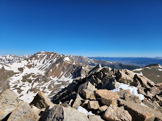
As the Columbia trail left the trails to traverse up one of the first large switchbacks there was a large snow patch to be crossed. It was at a very low angle so no problems yet on the snow. After that crossing there was really no other snow to be concerned about on the Columbia ascent. I enjoyed taking pictures along the way as the last time I was up here my son Luke and I had near whiteout conditions on the upper parts of the mountain. The views were fantastic. I made good work of the summit ridge of Columbia and the brief bit of scrambling to gain the top. I had planned to take 3:15 to summit Columbia from the North Cottonwood TH figuring Luke and I had done it in 4:06 2 years prior and were at a more leisure pace. Today I topped out in 3:06, putting me 12 minutes up on the day's plans. Sounds good but this was also where the good would stop.
 |
| Approaching Columbia's summit |
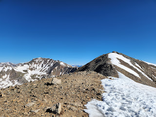
I've never descended off Columbia to the north. When I last did the traverse with my friend Matt we had done it from Harvard. I remember little of Columbia's ascent from that direction as we were being chased by storm clouds and were high-tailing it out of there. I probably still haven't seen a clear and open north side of Columbia. Today it was completely snow-covered. For the most part this was a good thing. As I checked the track on my GPS to get a good bearing I set downhill and it didn't take long before glissading became the best option. The snow was in fairly good condition for this so I put together a couple of good glissades which dropped me down into a nice big bowl of a snowy meadow on the traverse. The route seemed to reveal itself as I made my way through the snow through the traverse. No traction or flotation was needed, the snow held together nicely. I had one traverse on a fairly steep slope with some run out but felt good on it with just trekking poles. On the plus side I felt the snow helped in that I wasn't talus hopping. On the down side, it still made for slow footing as the snow continued to soften for the day.
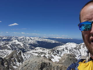
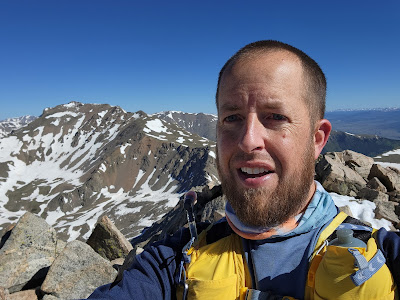 |
| Summit selfie on Columbia |
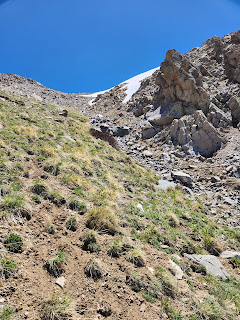
I tried to keep my lines tight and without taking on much extra distance as I wound my way towards Harvard. When the ascending began on Harvard the snow began to thin again. Outside the protection of the connecting ridge between Harvard and Columbia things were a little more wind swept. I would still dodge a few more snow patches on my ascent up to Harvard. The real challenge came in the range of 14200 in the difficult rock as the ridge narrows nearer the summit. Some sketchier snow guarded some of the path and the scrambling here slowed me down.
 |
| Snow off the north side of Columbia |
 |
| Snow covering the traverse |
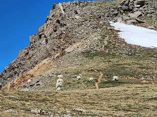 |
| Goats guarding passage up to Harvard |
 |
| Terrain gets more difficult heading for Harvard's summit |
I finally topped out on Harvard at 11:33am. This was 2:18 from Columbia and much slower than expected. I'm fairly certain the snow did not help my speed. I only spent a minute on top taking a few pictures and then gaining my bearings for the descent. I knew the Harvard summit was one of the more difficult ones in the Sawatch. I moved east just a bit and then found a spot where I could make a short, difficult glissade between rocks to some easier ground. Its fairly steep going north of the summit and here again the snow didn't help, at least not at first. I had been hoping to make good time on easier terrain heading down Harvard's north ridge but again softening snow was slowing things up.
 |
| Descending the west side of Harvard's north ridge |
I was able to use my GPX track to find the descent off the west side of the ridge and at first there even appeared to be a faint trail. The upper portion actually made for good descending at first and I was feeling good. Then a snow field picked up just as my route was nearing an obvious chute. Here I likely made my biggest mistake of the day. I began a steep glissade and nearly lost control. I came in pretty hot to a large rock at the bottom and I braced for impact. Thankfully I seemed to have slowed down just enough before I hit to not take on any injury. From there I avoided the snow and hugged the steep scree at the edge of the chute. It was here I began to realize my other big mistake of the day. I was getting behind on calories. In my haste to keep moving I'm sure I was forgetting to eat. I could feel it in my legs. The steep descending didn't help. I took several slip falls on my behind on the steep loose terrain. My ankles were hurting as well. It was tough.
 |
| Looking up the steep chute |
At the bottom of the chute I found easier terrain but I was also running out of water. I could see ahead a creek I knew about on the map. Only it was mostly snow covered. I was able to find an area that had melted open and thankfully was also narrow enough for me to hop. I really didn't want to test a melting snow bridge today. It also made for a great spot for a quick water filter.
 |
| Soggy, snowy bushwhacking |
The terrain between me and Pine Creek became much harder than I had anticipated. I was hoping for a fun, beautiful bushwhack and instead I found a snow-covered difficult to navigate quagmire. I kept thinking I needed to head to my right down to the creek but my GPS kept telling me I wasn't nearly far enough west yet. I really struggled to work my way ahead. At another big creek crossing I got myself stuck again. I didn't want to test snow bridges over the rushing creek but I also couldn't find safe crossing. I ended up having to bushwhack thick, tall willows along a narrow path by a rock wall downhill til I could finally find a place to hop the creek. I knew I had a mess but I was at least staying safe.
 |
Creek crossing ahead under all the snow
|
I finally found my way down to Pine Creek and it also took a few moments to find a crossing. On the other side I checked my watch and had a big decision to make. I was already tired and hurting and mentally had just exhausted myself. My gameplan for the day would have had me summiting Missouri at 1:27pm and I was only making it to Pine Creek at 1:22pm. Bad news. I could also see most of the route up to Elkhead Pass was still snow so the option of skipping Missouri and going for the other two peaks was not an easier one either. My plan would have had me hitting the car at 9:15pm, right around dark. It was likely I would at least run 2 hours past that if I went on for more peaks. I made the tough decision to bail on Missouri, Belford, and Oxford. I would hike the Pine Creek trail out to the CT and then take that back to my car. It felt like a failure not getting the peaks I wanted. On the other hand, I still had 18 miles to go and I would still accrue over 30 for the day. It actually felt weird knowing I was quitting on the bigger objective and "calling it quits", but I hadn't even done half my mileage yet for the day.
What I did do was take about 20 minutes there at Pine Creek to rejuvenate. I downed a bunch of food and water and tried to make sure I would recover energy and be feeling better for the hike out. I could reclaim my body even if I couldn't reclaim the time lost.
 |
| Finally heading out Pine Creek |
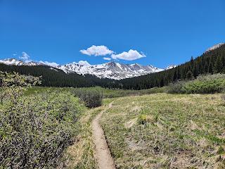
The hike out Pine Creek was mostly uneventful. The first mile or two still had some patchy snow and then that cleared for good. While hiking by the marshes I saw a moose about 100 yards off trail. I watched her a bit while taking pictures, and then moved on. As I neared the CT junction I encountered a group of a dozen or so. These were the first people I had seen since dropping off Columbia. In fact, up to this point I had passed only one hiker going up Columbia, one hiker coming down, and then this group. The only people I saw the whole day.
At the CT junction I filled up a liter of water and then continued on for the 11 more miles to the car. The first half of this section of the CT I had never been on before. It was also has a sneaky climb going from 10400 back up to 11800. A 1400 foot climb on already tired legs was rough but I knew it was coming. At least the views were good and there was no snow. I passed the time listening to several podcasts reviewing the Western States 100 which had just taken place two days prior. Leadville resident and ultrarunning GOAT Courtney Dauwalter had obliterated the course record.
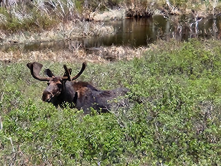 |
| My moose friend |
 |
| Looking back up to Emerald and Iowa on the hike out |
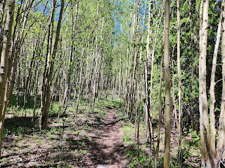 |
| Beautiful aspens |
The rest of the hike out went uneventful and other than my feet finally taking on some soreness over the last 4 miles things went well. I did one more water fill at Frenchman Creek making for five on the day and probably totalling 7-8 liters consumed.
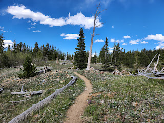 |
| Topping out at 11800 on the CT |
The totals were just over 31 miles and roughly 10,000 feet of gain. The climb was a personal record for a single day. As I reflect on how the day went I'm still intrigued by the question of whether this was a failure since I didn't meet my overall goal, or whether it was still a success given I completed the majority of the loop and still took on 50K of mileage. I remember weighing similar questions when I had to DNF my first attempt at the Marquette Trail 50 in the UP of Michigan. It seems when you have an open mind there are always consolations to take in even when the day doesn't go as planned. Ultimately, I love the mindset that in ultras and adventures there's never really a failure if you go out and have fun and enjoy the day and for this one I certainly did. I loved all the time spent planning and anticipating. I did love the day even if the snow and my nutrition failures led to some changes in the end.
 |
| Cruising on the CT |
 |
| Harvard Lakes |
 |
| On the final descent back to the Harvard Lakes TH |
Track:
I have a track and waypoints from the activity all contained in the embedded Google Map. Check it out and use at your own risk.

 I'm learning to become old acquaintances with challenges and failure. I chose to tackle a big self-made adventure again this year with high aspirations, but it didn't quite go as planned. I've been doing ultras for several years now and I decided my big goal for summer 2023 was what I would call an "adventure ultra", that is, not a sanctioned race but rather an ultra length adventure of my own making. I wanted to create my own route and then see if I could complete it. Half the adventure would simply be in the weeks and months of planning for this adventure and that part went exactly to plan.


.jpg)


No comments:
Post a Comment