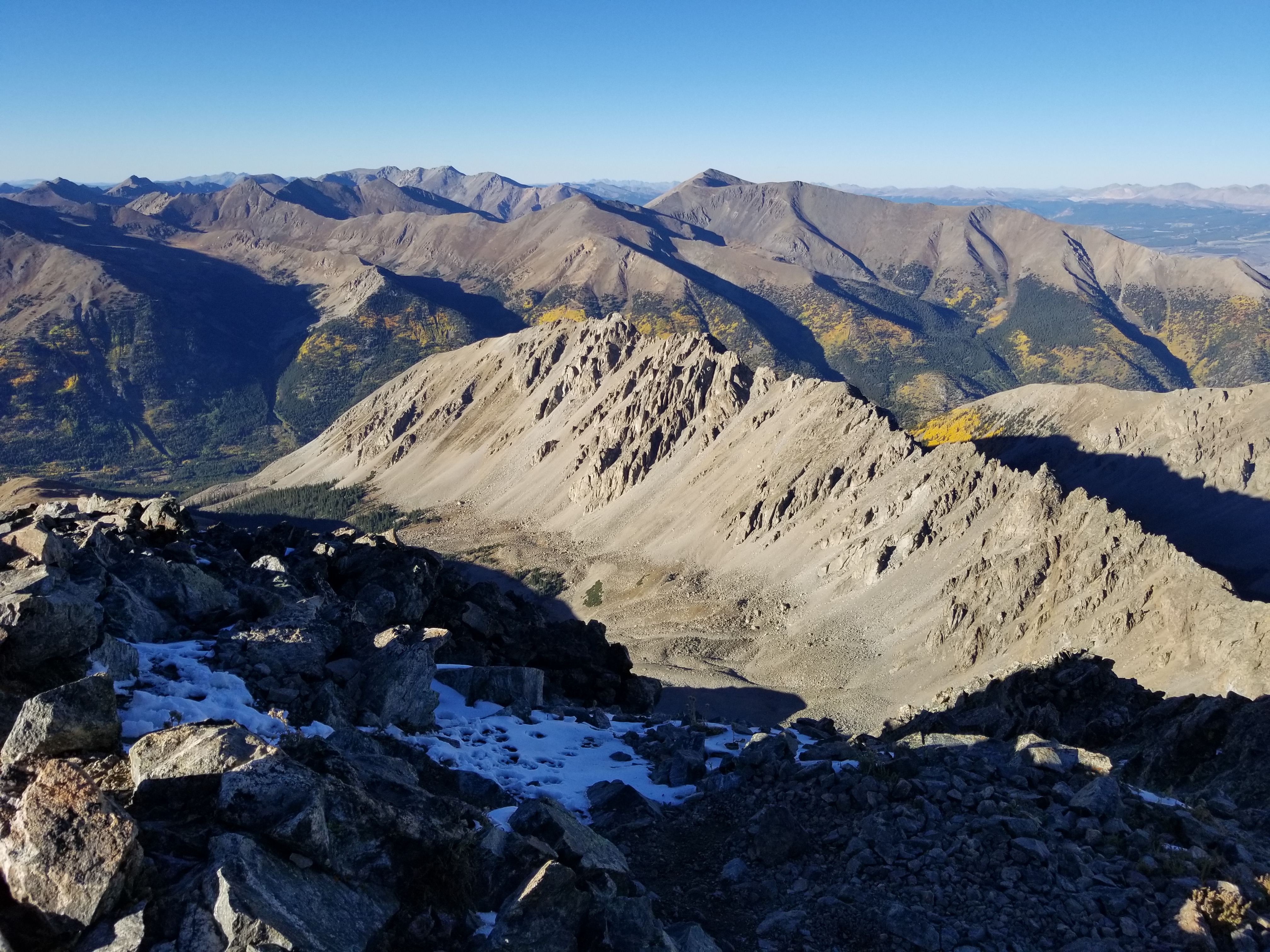
 There were some who questioned our decision to hike the Decalibron on the 4th of July with all the potential crowds. It was a reasonable question. But the crowds weren't the issue for us today. While there were a fair amount of people on trail in the relatively short time we were up there, that wasn't really the problem. In fact, we've now spent 2 years in a row on 14ers on the 4th of July and it becomes quite fun to wish random people on the trail "Happy 4th" as you enjoy what should be a favorite pastime of America: enjoying our beautiful outdoors.

Showing posts with label 14ers. Show all posts
Showing posts with label 14ers. Show all posts
Friday, July 4, 2025
Mt. Democrat 2025
There were some who questioned our decision to hike the Decalibron on the 4th of July with all the potential crowds. It was a reasonable question. But the crowds weren't the issue for us today. While there were a fair amount of people on trail in the relatively short time we were up there, that wasn't really the problem. In fact, we've now spent 2 years in a row on 14ers on the 4th of July and it becomes quite fun to wish random people on the trail "Happy 4th" as you enjoy what should be a favorite pastime of America: enjoying our beautiful outdoors.
Thursday, July 3, 2025
Mt. Massive and South Massive Peak

As my father and I looked for backpacking and camp options for our 2025 travel I planned a return to the basin. The initial plan was to camp and likely hit Oklahoma. It seems a great Centennial summit and a fun bit of bushwhacking to get it. When my two sons and I finally got down to it we ultimately decided on Massive so they could get a new 14er summit. We made plans for the Southwest Ridge route on Massive which my father and I had previously done in 2018.
Thursday, July 4, 2024
Mount Shavano 2024

Trip Info:
East Slopes route
Trailhead Elevation: 9,782 ft.
Summit Elevation: 14,230 ft.
Distance: 12.04 mi. (inflated from the norm 9.5mi for Shav)
Elevation Gain: 4,755 ft.
Start Time: 7:59am
End Time: 5:18pm
Wednesday, July 3, 2024
Huron Peak 2024
 This was my third trip to Huron Peak and it is one that I will always be happy to return to. It is a beautiful route and not overly difficult. The summit views are some of the best in the state. It is definitely a mountain worth repeating. Here in 2024 I was in Colorado preparing for the Silver Rush 50 race on Saturday July 6. We had Wednesday and Thursday free for acclimatizing hikes leading up to the race. The goal was to toe the line between getting some high altitude time and work without blowing up the body. I've done this a couple times in the past preparing for the Pikes Peak Marathon in 2016 and Run Rabbit Run in 2019. I also had my father, brother, and two of my sons along and we wanted to have a great fun hike and also a new one for my two boys..
Trip Info:
Northwest Slopes Route from 4WD TH
Trailhead Elevation: 10,588 ft.
Summit Elevation: 14,003 ft.
Distance: 8.91 mi.
Elevation Gain: 3,835 ft.
Start Time: 7:47am
End Time: 3:26pm
Distance: 8.91 mi.
Elevation Gain: 3,835 ft.
Start Time: 7:47am
End Time: 3:26pm
Monday, June 26, 2023
Harvard & Columbia Circumnavigate
 I'm learning to become old acquaintances with challenges and failure. I chose to tackle a big self-made adventure again this year with high aspirations, but it didn't quite go as planned. I've been doing ultras for several years now and I decided my big goal for summer 2023 was what I would call an "adventure ultra", that is, not a sanctioned race but rather an ultra length adventure of my own making. I wanted to create my own route and then see if I could complete it. Half the adventure would simply be in the weeks and months of planning for this adventure and that part went exactly to plan.
While my big ultra adventure didn't go exactly as planned its hard to say that it was a total failure. I fell short of my ultimate goals but I still accomplished a lot and I didn't quit in big ways where I easily could have. Perhaps most importantly, I had a great time and still put a wonderful challenge to myself and felt very good about it in the end.
Saturday, September 24, 2022
Ellingwood Ridge - La Plata Peak
 Ellingwood Ridge route to East La Plata and then La Plata's summit and then descent on the northwest ridge (standard) route.
Trailhead Elevation: 10,161 ft.
Ellingwood Ridge Summit: 13,220 ft.
East La Plata Summit: 14,186 ft.
La Plata Summit: 14,344 ft.
Distance: 12.30 mi.
Elevation Gain: 6111 ft.
Start Time: 7:18am
End Time: 8:13pm
Trip Report:
Both the blessing and the curse of this ridge is that you have to make it. There's no turning back. It is quite possibly the most committing route in all the state of Colorado. There is no escape.
Sunday, October 10, 2021
Marl Lake Trails (South Higgins Lake State Park)

Marl Lake Trail Loop B (Red)
Trailhead Elevation: 1,155 ft.
Distance: 2.76 mi.
Elevation Gain: 27 ft.
Start Time: 5:52pm
End Time: 6:35pm
Trip Report:
The Marl Lake Trails are three loops that hug the west and south sides of Marl Lake which is just south of Higgins Lake. They are easily accessible from I-75 and not too far south of Grayling. I was travelling up north for a conference in Bellaire and hoping to find a new hiking location along the way. This hit the spot perfectly. I figure it was a less than 15 minute detour off the interstate to hit the easy trailhead.
Sunday, August 1, 2021
Mount Columbia - West Slopes

Trailhead Elevation: 9,910 ft.
Summit Elevation; 14,073 ft.
Distance: 12.45 mi. (my Forerunner 235)
Elevation Gain: 4,121 ft. (my Forerunner 235)
Start Time: 5:00am
End Time: 12:22pm
Trip Report:
I've been eyeing the west slopes route of Columbia for a couple of years now as the Colorado Fourteeners Initiative poured in a ton of resources to build a new trail for this route. I had previously descended the original "trail" in 2010 after completing the Harvard-Columbia traverse with my friend Matt. I can remember the steep and loose nature of the previous trail. It was almost universally disliked by all. So I had great excitement to see the miracle trail work of CFI to update this route.
Saturday, July 31, 2021
Yale Silver Creek Loop

Trailhead Elevation: 9,419 ft.
Yale Summit Elevation: 14,196 ft.
Denny-Browns Jct Elevation: 10,747 ft.
Upper Brown's Pass Elevation: 12,530 ft.
Distance: 19.93 mi. (my Forerunner 235)
Elevation Gain: 6,710 ft. (my Forerunner 235)
Start Time: 4:42am
End Time: 1:03pm
Trip Report:
For several years now I've been eyeing long and longer routes and link-ups of trails to see how I can handle bigger and bigger days in the mountains. There is a certain joy in looking at a map and being able to cover large amounts of grand especially when you can keep hitting new trail the whole day. This effort was to make a wonderful loop around and including Mount Yale. I've seen others do a similar route only instead of going up and over Yale they do a complete circumnavigation of the peak using the Cottonwood Pass Road and the Avalanche Gulch portion of the CT which I skipped. While I love the aesthetic idea of a complete loop around the peak the thought of going up and over it seemed more enticing for my style.
Thursday, July 29, 2021
Emerald-Iowa-Missouri Loop
 |
| Just amazing beauty up here |
Camp Start Elevation: 11,634 ft.
Emerald Peak Elevation: 13,904 ft.
Iowa Peak Elevation: 13,831 ft.
Missouri Mountain Elevation: 14,067 ft.
Distance: 7.10 mi. (my Forerunner 235)
Elevation Gain: 3,190 ft. (my Forerunner 235)
Start Time: 6:57am
End Time: 12:04pm
Trip Report:
In researching adventures to get into while backpacking up into Pine Creek/Missouri basin it quickly became evident that several peaks would be within reach in one big push. Two large 13ers, Emerald, and Iowa as well as 14er Missouri all sit next to each other on a long ridge. An early question we dealt with was what this ridge would look like and whether it would get technical. Some research on old trip reports revealed that the ridge was fairly tame and very do-able with our skill set. I was even able to find another individual's GPX track of a route they took to hit these peaks and I had that with me on my phone app as a guide.
Tuesday, July 27, 2021
Magdalene Mountain & Silver King Lake

Start Elevation: 11,633 ft.
Lake Elevation: 12,650 ft.
Summit Elevation: 13,752 ft.
Distance: 5.06 mi. (my Forerunner 235)
Elevation Gain: 2,118 ft. (my Forerunner 235)
Start Time: 12:24pm
End Time: 4:38pm
Trip Report:
As part of our backpacking trip into the high portion of the Pine Creek/Missouri Basin we were looking for further objectives to hike to once we setup a high camp. This morning we hiked up near the junction of the Pine Creek Trail and Elkhead Pass trail and found a good campsite a quarter mile up from the junction. We set things up, had a nice lunch, and then set out to hike up to the lake. The plan was for my father Denny and son Luke to have fun fishing at the lake while I set out for the 13er Mount Magdalene.
Pine Creek Backpacking
 Pine Creek Trail plus other adventures.
First Camp Elevation: 10,970 ft.
High Camp Elevation: 11,640 ft.
Total Trip Distance: 33.33 mi. (my Forerunner 235)
Total Trip Elevation Gain: 8,223 ft. (my Forerunner 235)
Start Time: Tues, July 27, 2:30pm
End Time: Thurs, July 29, 5:48pm
Trip Report:
If you're looking for some truly classic Colorado backpacking, and are willing to put in the miles and the work to get it, backpacking up the Pine Creek trail is a worthy choice. It is a lengthy 10+ miles to get deep into the basin but the trail is good and well worth it. My father and I have been eyeing this hike for many years now but have never found the opportunity to pull the trigger. We've even caught glimpses of the this beautiful area from the summits of the surrounding 14ers like Harvard and Missouri. When my son Luke and I stumbled into a few days of free travel time to head out to Colorado and join my father the perfect opportunity presented itself.
Friday, April 9, 2021
Quandary Peak Winter 2021

Trailhead Elevation: 10,850 ft.
Summit Elevation: 14,265 ft.
Distance: 7.51 mi. (my Forerunner 235)
Elevation Gain: 3,435 ft. (my Forerunner 235)
Start Time: 7:30am
End Time: 3:35pm
Trip Report:
We picked a beautiful, ultimately blue-bird day to seek the summit of Quandary. During our drive through South Park and up to Hoosier Pass though we weren't so sure if would turn out like this. Clouds had the Mosquito Range and southern Tenmiles socked in as we drove on approach. Over Hoosier Pass there was a fresh half inch of snow on the roadway and we saw multiple cars losing traction. We were just glad to safely make the trailhead to start our day.
Thursday, July 23, 2020
Mt. Harvard Traverse

Start Elevation: 9,414 ft.
Summit Elevation: 14,420 ft.
Finish Elevation: 9,892 ft.
Distance: 14.30 mi. (my Forerunner 235)
Elevation Gain: 5300 ft. (my Forerunner 235)
Start Time: 5:37am
End Time: 1:46pm
Trip Report:
I've had my eye on a return trip to Harvard in recent years. I first climbed it in 2010 with my friend Matt when we did the Harvard-Columbia traverse from our campsite in Horn Fork Basin. I instantly fell in love with the area. I wanted to change the route up slightly this time. I had read good things about the Frenchman Creek approach and decided to make a scenic up-and-over route on Harvard to keep things fresh. With all of this being relatively close to my folks place in the BV area we had an easy way to get vehicles in place for the two trailheads we'd be using.
Wednesday, September 11, 2019
La Plata Peak - Southwest Ridge
 Southwest Ridge Route
Trailhead Elevation: 3,923 ft.
Summit Elevation: 14,336 ft.
Distance: 8.49 mi.
Elevation Gain: 3,611 ft.
Start Time: 7:20am
End Time: 2:39pm
Trip Report:
La Plata has been my go-to warmup peak for big mountain races in Colorado. You might figure I look at it as my lucky charm for running success, but that isn't quite the case. I used La Plata in 2016 as an acclimatizing peak before I ran the Pikes Peak Marathon. It helped with the altitude training, but I nearly wrecked my quads while running down the mountain. Nonetheless, I wanted to use it again here in 2019 to help me acclimatize before the Run Rabbit Run 50. I intentionally went slow on the ascent and descent. My quads survived nicely. However, I somehow came away with a small bit of soreness in my calves from the steep climbing on the southwest ridge. Despite our battles together, I do love this mountain and regard it as one of my Colorado favorites.
Friday, June 28, 2019
Mt. Antero + Mt. White via Little Brown's Creek

Brown's Creek Trail to Colorado Trail to Little Brown's Creek Trail
Trailhead Elevation: 8,914 ft.
Mt. Antero Elevation: 14,269 ft.
Mt. White Elevation: 13,667 ft.
Distance: 17.34 mi.
Elevation Gain: 6,165 ft.
Start Time: 5:35am
End Time: 2:11pm
Trip Report:
In 1993, Mount Antero became the fifth 14er I climbed. I was a young teenager and hiking to the tops of mountains was still very new to me, but it was quickly becoming something I enjoyed. My main recollection of that hike from 26 years ago was riding in my uncle's jeep to around 13,000 feet and thinking how nice it was to shorten this otherwise long hike. A small part of me felt like it was cheating a bit, but then I was only 13 and the thought of hiking 16-17 miles was out of the question.
Monday, July 16, 2018
Mt. Elbert 2018
 Mt. Elbert
Northeast Ridge route (Standard)
Trailhead Elevation: 10,064 ft.
Summit Elevation: 14,433 ft.
Distance: 10.18 mi.
Elevation Gain: 4,370 ft.
Start Time: 6:23am
Summit Time: 10:11am (43 minutes on top)
End Time: 2:16pm
Trip Report:
We found ourselves heading to Mt. Elbert today after having to be adaptable in our vacation's planning. Yesterday was essentially rained out and forced us to scrap our original plans. We wanted to backpack into Holy Cross but doing so in the rain didn't seem all that enticing. This meant Sunday was lost to us. On the other hand, it freed up Monday for a fun dayhike. My oldest son Luke hadn't been up Elbert yet and we decided this would be a fun repeat for us older guys. I had previously been up Elbert in the winter in 2012 and in the summer in 2005. Our winter hike went up the East ridge while the original summer hike went up the standard Northeast ridge.
Saturday, July 14, 2018
Quandary Peak Traverse + Fletcher Mt.
 Quandary Peak Traverse + Mt. Fletcher
Blue Lakes Reservoir Approach to Mt. Fletcher + Quandary West Ridge + Quandary East Ridge
Trailhead Elevation: 10,842 ft.
Blue Lakes Dam Elevation: 11,707 ft.
Mt. Fletcher Elevation: 13,951 ft.
Quandary Peak Elevation: 14,265 ft.
Distance: 9.81 mi.
Elevation Gain: 3,928 ft.
Start Time: 6:18am
Fletcher Summit: 8:59am (12 mins)
Quandary Summit: 11:17am (19 mins)
End Time: 1:15pm
Trip Report:
My brother David and I were looking for a thrilling challenge today that would put us on a peak with a good weather forecast. Our original plan was to ascend La Plata Peak by the classic Ellingwood Ridge but the forecast was less than favorable for a challenge that demands perfect weather. Instead, we decided on the West Ridge of Quandary which had a more favorable forecast and a less-time consuming demand.
Thursday, June 7, 2018
Mt. Yale Traverse
 Colorado Trail - Silver Creek TH to Mt. Yale East Ridge to Mt. Yale Southwest Slopes
Silver Creek Trailhead Elevation: 9,416 ft.
East Ridge Start Elevation: 11,919 ft.
Summit Elevation: 14,196 ft.
Denny Creek Trailhead Elevation: 9,924 ft.
Distance: 10.30 mi. (my Forerunner 230)
Elevation Gain: 4,870 ft. (my GPS)
Start Time: 6:07am
East Ridge Start: 7:41am
Summit Time: 9:39am (14mins)
End Time: 11:51am
Trip Report:
There is something elegant about a full traverse of a mountain. This may be one of those "beauty is in the eye of the beholder" sort of things, but I believe in it. For years now I have been intrigued with finding and exploring new routes in the mountains, particularly when you can ascend one route and descend another. Perhaps the origin of this desire could be traced to my love of Tom Hornbein's "Everest: West Ridge" where Hornbein and Willi Unsoeld incredibly completed the first traverse of Mt. Everest by ascending the deathly West Ridge and descending the more standard South Col route. It was death-defying.
Wednesday, June 6, 2018
Mt. Massive - SW Slopes
 Mount Massive
Southwest Slopes route
Trailhead Elevation: 10,572 ft.
Distance: 8.27 mi. (my Forerunner 230)
Elevation Gain: 3,860 ft. (my GPS)
Start Time: 7:34am
SW Slope Route Junction: 8:28am
Summit Time: 11:56am (27 mins)
SW Slope Route Junction: 3:04pm
End Time: 3:56pm
Trip Report:
For a few years now Mt. Massive had been rising up my list of 14ers that I wished to return to. Most of the 14ers that we did in the 90's are in this growing time frame of 20+ years since we were there. They also fit the bill of hikes that, in my teens, I just didn't remember well due to teenage "lack of focus". I'd been looking for the right opportunity to return to Massive and had begun researching all the most enjoyable options. I'd read a few reports, even started researching a particular track of a full Mount Massive Traverse. This would be an epic long day. It would follow the east slopes route up to the summit ridge, would summit South Massive, then head to the main peak and then North Massive with a decent off the north side of the mountain. Maybe a trip for another day, but not this day.
Subscribe to:
Posts (Atom)
Popular Posts
-
 Penosha Trail: Brighton State Recreation Area Trailhead Elevation: 921 ft. Distance: 4.8 mi. (my GPS) Elevation Gain: 834 ft. (my GPS) ...
 -
 Ash Hollow State Historic Park / Oregon National Historic Trail Windlass Hill Trail Trailhead Elevation: 3,500 ft. Distance: 0.63 mi. (ro...
 -
 Route Name: Dewey Lakes Trails Start Elevation: 36 ft. Lake Elevation: 3,083 ft. Distance: 5.6 mi. Elevation Gain: 3,155 ft. Start Tim...
 -
Route Name: South Ridge from Nellie Creek Start Elevation: 11,400 ft. (4WD TH) Summit Elevation: 14,309 ft. Elevation Gain: 2909 ft. Rou...
-
 Anglemeyer Lake Backpacking North Cottonwood Creek trail into Horn Fork Basin + Bushwhacking to Anglemeyer Lake Trailhead Elevation: 9,887...
 -
 Photo Point Trail + Nugget Falls Trail at Mendenhall Glacier Tongass National Forest Trailhead Elevation: 83 ft. Distance: 2.10 mi. (my F...
 -
 Frisco -> Mt. Royal Trail -> Mt. Victoria -> Peaks 1-10 -> Breckenridge Ski Resort Trailhead Elevation: 9,094 ft. Distance: 16...
 -
 Mt. Washington to Lakes of the Clouds Crawford Path and Appalachian Trail Summit Elevation: 6,228 ft. Lakes Elevation: 5,051 ft. Dista...
 -
 Pine Creek Trail plus other adventures. Trailhead Elevation: 8,806 ft. First Camp Elevation: 10,970 ft. High Camp Elevation: 11,640 ft. Tota...
 -
 Jump to Lake Michigan Overlook Climb Sleeping Bear Point Trail Sleeping Bear Point is at the northern end of the National Lakeshore. It is ...