The North Halfmoon Creek basin is quite the lovely place. I've been eyeing some camping and exploring up there for several years now. My brother and I had at one time planned a summit of Oklahoma with a traverse over to Massive but it never quite came to fruition.
As my father and I looked for backpacking and camp options for our 2025 travel I planned a return to the basin. The initial plan was to camp and likely hit Oklahoma. It seems a great Centennial summit and a fun bit of bushwhacking to get it. When my two sons and I finally got down to it we ultimately decided on Massive so they could get a new 14er summit. We made plans for the Southwest Ridge route on Massive which my father and I had previously done in 2018.
Trip Info:
SW Ridge Trail to Massive SummitEast Slopes Trail to Massive Trailhead
N. Halfmoon Creek Trailhead Elevation: 10,486 ft.
Massive Summit Elevation: 14,421 ft.
South Massive Elevation: 14,132 ft.
Massive Trailhead Elevation: 10,095 ft.
Distance: 13.00 mi.
Total Ascent: 4404ft.
Total Descent: 4795ft.
Start Time: 6:01am
End Time: 2:59pm  Trip Report:
We drove in the afternoon of July 2 and found a lovely campsite just a couple hundred feet from the trailhead. It was a grassy meadow with plenty of open space and a few flat spots for our tents. We made a fun evening of it with a nice campfire and some good food.
The July 3 forecast showed the weather deteriorating after noon so we decided on a 6am start from the trailhead with hopes of summitting at 10am or sooner. My father would stay back at camp and tear it down and wait for word from us for a pickup time. He planned to drive out to Leadville for coffee and some relaxation.
I wore my blue Salomon Speedcross 4 shoes today and had a surprise when I put them on. I had forgotten they had the sheet screws in them from the group run I had done at Proud Lake back in February. The trails were very icy that day and most people were putting screws in for needed traction.
We made quick work of the first two miles of the trail as it moves deeper into the basin. We had a 15 minute bathroom stop but otherwise found ourselves at the junction for Massive's SW Ridge at 6:53am. Here the climbing really began. I had warned my boys how steep it was and it lived up to its billing. In the lower stretches it is a consistent climb and we took it in stride. I was pleased to see my boys enjoying themselves with the challenge as we made consistent progress. We had another group catch us and pass us as we ascended and we ourselves caught two other groups and passed them up.
 |
I think this was looking to the south
at French Mountain |
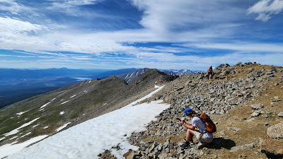
The views on the upper stretches were quite wonderful. We were also pleased to find numerous columbines as well as marmots. The trail remained good and easy to follow up to the point on the ridge at around 14250 where it meets the East Slopes route. Here we encountered several parties who were ascending the standard route. The remaining summit ridge had a bit more snow than we were expecting and we watched some of the groups ahead to see what path they were taking. This is an area where it truly looks more difficult than it is. At first glance you might be wondering if you just got yourself into some class 3 with route-finding, but it doesn't turn out that way.
 |
Mt. Oklahoma coming into view
in the background |
We did get off route a little following some other parties around a snow field. (We realized later on the descent what we had done, and followed a much more direct and easy path to descend). The weather was delightful and even the temp reasonable for an early July summit. We made Massive's summit at 9:34am for a 3:33 ascent. It was about 45 mins faster than my father and I had done it 7 years ago. We enjoyed the summit with a dozen other new friends for about half an hour taking photos, making some phone calls and using Peakfinder to take in all the summits in view.
 |
| On the ascent, Mt. Elbert on the left |
 |
| Looking at French and Casco |
 |
Looking over at South Massive
(no easy shortcut from here) |
 |
| Summit Ridge |
 |
| Group summit selfie |
 |
| To the west from Massive's summit |
 |
| Time for the descent |
 |
| Mountain goat hanging out on route |
We descended off the summit ridge with little fanfare. Along the way we had some decision-making. One of my son's has been battling tendinitis in his knee and descending was becoming quite challenging for him. We debated between the shorter but steeper SW Ridge route which we had ascended, or whether to try the longer but much less steep East Slopes route. The latter would also benefit my father who could pick us up at a much easier trailhead and not have to retrace his route on the 4WD section. We decided to descend the East Slopes.
 |
| The easy climb up to South Massive |
We also made the decision to go for the South Massive (unofficial) summit while we were up there. I kinda felt if I didn't do it today, I would probably never do it. My son Luke and I headed over there while my son Seth decided to continue the descent. From the saddle between Massive and South it only took us 14 minutes to get to South Massive's summit. It was a fairly straightforward, low class 2, hike to the top.
We rejoined my other son a mile or so down the East Slope route. This is a long but a beautiful route with wide open views of Leadville and the upper Arkansas valley. It really was a nice route to descend to soak in those views the whole time in the alpine. The only thing we weren't as much looking forward to was the 3+ miles on the Colorado Trail down in the trees. Two days prior we had a 21-mile day on the Colorado Trail hiking from Lake Ann towards Texas Creek and ultimately Hartenstein Lake. As much as 15 miles of that were entirely in the trees and we had had quite our fill of tree miles.
 |
| Looking at Elbert from South Massive |
We were happy to have good communication options today to work out our pickup. Since the East Slope route faces Leadville we had cell signal most of the descent. We also had my fathers Garmin in reach mini in case that didn't work. We sorted out a pickup time at the Mt. Massive TH with my father and he met us there when we arrived at 1:58pm. The descent was 3:52 on the East Slope route including the 25 minute or so detour to South Massive.
 |
| Plenty of marmots on East Slope! |
 |
| Beautiful descent on the East Slope |
 |
| Looking back up to the summit |
Track:
I have a track and waypoints from the activity all contained in the embedded Google Map. Check it out and use at your own risk.


 Trip Report:


.jpg)


No comments:
Post a Comment