Text
✝ See Published Articles for my old Faith Columns and other content.
⛰ My blog also contains numerous Trip Reports from adventures I've had.
Monday, September 1, 2025
Mackinac Bridge Labor Day Walk 2025
Saturday, August 30, 2025
Marquette Marathon 2025
Friday, October 18, 2024
Sleeping Bear Point and Lake Michigan Overlook Climb (Sleeping Bear Dunes)
Sleeping Bear Point is at the northern end of the National Lakeshore. It is just west of Glen Arbor. There is a nice parking lot trailhead at the end of a dirt road. I did this loop trail counterclockwise. In this direction it begins on pure sand and very quickly comes to a junction where you can turn right and go about 2/10 of a mile down to the Lake Michigan beach. Definitely worth it especially if you have kids to go and explore and enjoy the sand and the beach. Once back to the loop it's meanders on the dunes and you follow blue posts to stay on route. For the most part it's fairly easy to keep on the route. You spend a lot of time on the sand with plenty of up hills and subsequent downs. The last 0.75 takes you into the woods on a beautiful single track with plenty of fall colors. I was engaged the whole loop hiking on my own and didn't for a second think of putting in my earbuds to pass the time. Definitely a winner of a trail and hike while visiting Sleeping Bear Dunes.
Tuesday, October 15, 2024
Vasa Pathway - 10K Loop

Monday, October 14, 2024
Deepwater Point Natural Area

Friday, June 28, 2024
Pinckney Blind Lake Backpacking Jun '24
This was my first backpacking adventure of 2024. Most of the year to this point has been spent training for the Silver Rush 50 which is coming up in just over a week. This adventure was an excuse to get away for some camping and couple it with my last big long run before the race.
Trip Info:
Potawatomi Trail
Trailhead Elevation: 888 ft.
Saturday, July 22, 2023
Pinckney Blind Lake Backpacking Jul '23

Trip Info:
Potawatomi Trail
Trailhead Elevation: 888 ft.
Sunday, January 1, 2023
Pinckney Blind Lake Backpacking Jan '23
![]() |
West end of Hiland Lake |
Trailhead Elevation: 888 ft.
Jan. 1 Hike In
Elevation Gain: 1224 ft.
Start Time: 2:53pm
End Time: 6:50pm
Jan. 2 Hike Out
Elevation Gain: 850 ft.
Start Time: 8:52am
End Time: 11:10am
Trip Report:
It was time for another go at Blind Lake. This would be night #12 at this lovely campground. In 2021 I made it there via a big hike on the Waterloo-Pinckney trail from Portage Lake. In the morning I had to bike from Blind Lake back to Portage Lake. The last time I did the standard Poto Trail hike to Blind Lake was 2019.
Wednesday, October 12, 2022
Jordan Valley Pathway Loop
Full loop of the Jordan Valley Pathway including a portion of the North Country Trail
Trailhead Elevation: 1,286 ft.
High Elevation: 1,318 ft.
Low Elevation: 721 ft.
Distance: 18.81 mi.
Elevation Gain: 2228 ft.
Start Time: 8:12am
End Time: 12:05pm
Trip Report:
I finally made the big loop at Jordan Valley. I first discovered this loop in 2016 and that year I did an out and back of 12 miles on the NCT portion of the trail. I was somewhat time limited and I didn't make it all the way to Pinney Bridge as hoped. In the years since I've explored short sections venturing out from Deadman's Hill but never did things work out to go for the whole loop.
Saturday, August 20, 2022
Marquette Trail 50 (2022)
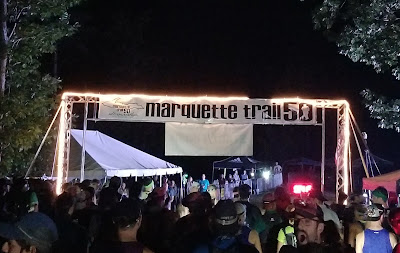
Finishing an ultra always comes with an immense sense of satisfaction. Hitting a finish line after many miles and hours out in God’s good creation on beautiful trails is an emotional experience. The sense of accomplishment is real and it just feels good. That sense is even greater when you return to a race that beat you up and dealt you failure in your previous attempt. My 2021 attempt at the Marquette Trail 50 was my first DNF and I’ve wrestled with it ever since. It wasn’t that this was a crushing blow to my ego or a defeat that tasted so bitter. I’m not really that kind of runner or person. I’m in this for the enjoyment, for the growth, for the learning and that DNF left me with so many questions. And yes, it did leave me with a desire to go back and finish what I started. That’s what brought me back, unfinished business.
In the end, I’ve reached a sense of contentment in saying my 2021 DNF at Marquette was due to a combination of three factors: (1) the hot weather of the day, (2) my quads being in an unusual pain due to the training effects of a medicine I was on, and (3) factors 1 & 2 exacerbating my concern of completely wrecking my legs before a trip with my brother to Isle Royale in the days following the race. I can live with my choices from that day and I accept what happened.
Friday, November 26, 2021
Waterloo-Pinckney Trail + Ride
Distance: 29.50 mi.
Elevation Gain: 1,099 ft.
Start Time: 8:32am
End Time: 6:40pm
Start Time: 8:50am
End Time: 10:47am
Trip Report:
This trip was the answer to the question: How do you hike a 30-mile point-to-point trail with one person and one car?" I've been wanting to make the Waterloo-Pinckney hike for a few years now to try out one of the longer trails in the great trail-state of Michigan. But short of having to make my wife drive a second vehicle to help me shuttle vehicles I hadn't yet found a good logistical way to make this happen. Then it dawned on me: use your bike.
Wednesday, October 13, 2021
Manistee River Trail Loop
Trailhead Elevation: 871 ft.
Distance: 21.16 mi.
Elevation Gain: 2159 ft.
Start Time: 7:51am
End Time: 12:59am
Trip Report:
I first heard of the Manistee River Trail when I saw a list of the Michigan Triple Crown of FKT Trails. They included the Waterloo-Pinckney Trail, the Pictured Rocks Lakeshore Trail and the MRT. I was quite frankly surprised I hadn't come across it sooner. It was clearly a classic Michigan Trail and so I wanted a chance to enjoy it. A conference up in Bellaire put me in the perfect range to give this a go.
Tuesday, October 12, 2021
Glacial Hills Pathway
Trailhead Elevation: 652 ft.
Distance: 5.27 mi.
Elevation Gain: 354 ft.
Start Time: 3:02pm
End Time: 4:45pm
Trip Report:
In researching trails in northwest Michigan I happened to stumble across the Glacial Hills Pathway as an enticing option. Then good fortune would bring me to Bellaire for a pastor's conference putting the GHP on the menu for afternoon free time.
Monday, October 11, 2021
Grass River Natural Area
Trailhead Elevation: 594 ft.
Distance: 3.18 mi.
Elevation Gain: 33 ft.
Start Time: 3:30pm
End Time: 4:21pm
Trip Report:
The Grass River Natural Area is a fantastic set of trails easily accessible from Bellaire and Traverse City Michigan. I found it while in Bellaire for a conference. It is open to the public and offers a number of easy to follow trails. The signage is plentiful and every junction is numbered. I set out looping south along the Chippewa and Nipissing loops. This crosses the Rail Trail and then heads south into the Algonquin Loop. I followed the east side of the loops back north to the original parking. For the most part each of these three loops was in the forest with no views. Being October the colors were starting to turn and the trail itself was a bed of leaves already.
Sunday, October 10, 2021
Marl Lake Trails (South Higgins Lake State Park)
Marl Lake Trail Loop B (Red)
Trailhead Elevation: 1,155 ft.
Distance: 2.76 mi.
Elevation Gain: 27 ft.
Start Time: 5:52pm
End Time: 6:35pm
Trip Report:
The Marl Lake Trails are three loops that hug the west and south sides of Marl Lake which is just south of Higgins Lake. They are easily accessible from I-75 and not too far south of Grayling. I was travelling up north for a conference in Bellaire and hoping to find a new hiking location along the way. This hit the spot perfectly. I figure it was a less than 15 minute detour off the interstate to hit the easy trailhead.
Tuesday, August 24, 2021
Isle Royale Greenstone Ridge
Monday - Lake Desor to Moskey Basin
Tuesday - Moskey Basin to Rock Harbor
Wrap-up
For our third great trail adventure together my brother and I chose Isle Royale National Park. Our previous two adventures took us to Grand Canyon and Grand Teton National Park. This year personal schedules kept us a little closer to the midwest and so Isle Royale became the choice option. My brother had been wanting to finally make it up there and I had been there previously in 2016. I also happened to have a 50-mile trail race in Marquette, Michigan in mid-August and a window opened for us to hit Isle Royale the day after my race.
One thing anyone who attempts to plan a trip to Isle Royale will quickly discover is that one of the most difficult parts of this adventure is actually planning it. Just getting to the island is an adventure on its own and numerous logistics around one's calendar need be navigated. To get to the island one has to use one of the three boat ferries or use a seaplane. The ferries have very specific daily schedules of when they'll get you to the island and when they'll take you off. This is only the first step.
Saturday, August 21, 2021
Marquette Trail 50 DNF
Every ultra is a learning experience. Without a doubt. It is part of the allure of running ultras. You never really know what is going to happen. Every single run is a new adventure. Running 5K's can become predictable as a 20-30 minute run is just short enough it doesn't leave much time for the unexpected. When you're on trail for 6-12 or more hours there is plenty that can happen. Plenty that can go wrong. Plenty that might just go right.
In my racing and running experiences up to this point things have mostly gone well. I've had races that didn't quite go as well as expected but I still finished them and held things together. I hadn't experienced what some would consider the dreaded "DNF", did not finish. I hadn't really come up face to face with a full-on failure. Then again, there are many in the sport who would argue a DNF shouldn't even be considered a failure. For some the only real failure is to not try in the first place. So there is a good discussion to be had about what a DNF means and how one can react to it. At the end of my race report I attempt to dig into this further.Wednesday, June 30, 2021
Two Hearted 50K Race
Predominantly on the North Country Trail
Start Elevation: 686 ft.Distance: 31.00 mi.
Elevation Gain: 545 ft. (my Forerunner 235)
Start Time: 6:53am
End Time: 12:33pm
Trip Report:
This was a fun return to most of a course I ran into 2017 when I did the Two Hearted Trail Marathon. This year was time to step up to another ultra and do the 50K. Officially I would list this as a training race for me as my main goal this summer is getting ready for the Marquette Trail 50. I did give this race my full attention, however, and feel I ran it about as hard as I could.
Saturday, July 4, 2020
Munising Falls and North Country Trail Run

Trailhead Elevation: 662 ft.
Distance: 0.45 mi. (likely longer, started a little late)
Elevation Gain: 179 ft. (my Forerunner 235)
Time: 4:48pm - 5:03pm
NCT Trail Run
Distance: 4.01 mi. (my Forerunner 235)
Elevation Gain: 322 ft. (my Forerunner 235)
Time: 6:30am - 7:24am
Trip Report:
If you make it to Munising in the Upper Peninsula of Michigan then it is well worth making the short journey to see Munising Falls. In fact there are at least a dozen different waterfalls to see up in this area and this might be one of the best of them. The trail starts at a visitors center for Pictured Rocks just east of the town of Munising.
Friday, July 3, 2020
Au Sable Lightstation (Pictured Rocks NL)
Distance: 3.43 mi. (my Forerunner 235)
Elevation Gain: 51 ft. (my Forerunner 235)
Start Time: 12:47pm
End Time: 2:24pm
Trip Report:
When it comes to the nuts and bolts of this hike there isn't a lot to say. It is a straightforward easy hike to follow and to complete. It leaves either from the day-use area at Hurricane River or from the west end of the lower campground. It follows a double-track gravel road out to the edge of the Lightstation complex. Once at the Lightstation there are several buildings to walk around and beautiful fields of wildflowers. Since our hike was during the coronavirus pandemic the buildings were all closed and the usual tour not offered. At the west end of the Lightstation complex the North Country Trail continues eastward toward Grand Marais.
Popular Posts
-
Penosha Trail: Brighton State Recreation Area Trailhead Elevation: 921 ft. Distance: 4.8 mi. (my GPS) Elevation Gain: 834 ft. (my GPS) ...
-
Ash Hollow State Historic Park / Oregon National Historic Trail Windlass Hill Trail Trailhead Elevation: 3,500 ft. Distance: 0.63 mi. (ro...
-
Route Name: Dewey Lakes Trails Start Elevation: 36 ft. Lake Elevation: 3,083 ft. Distance: 5.6 mi. Elevation Gain: 3,155 ft. Start Tim...
-
Route Name: South Ridge from Nellie Creek Start Elevation: 11,400 ft. (4WD TH) Summit Elevation: 14,309 ft. Elevation Gain: 2909 ft. Rou...
-
Anglemeyer Lake Backpacking North Cottonwood Creek trail into Horn Fork Basin + Bushwhacking to Anglemeyer Lake Trailhead Elevation: 9,887...
-
Photo Point Trail + Nugget Falls Trail at Mendenhall Glacier Tongass National Forest Trailhead Elevation: 83 ft. Distance: 2.10 mi. (my F...
-
Frisco -> Mt. Royal Trail -> Mt. Victoria -> Peaks 1-10 -> Breckenridge Ski Resort Trailhead Elevation: 9,094 ft. Distance: 16...
-
Mt. Washington to Lakes of the Clouds Crawford Path and Appalachian Trail Summit Elevation: 6,228 ft. Lakes Elevation: 5,051 ft. Dista...
-
Pine Creek Trail plus other adventures. Trailhead Elevation: 8,806 ft. First Camp Elevation: 10,970 ft. High Camp Elevation: 11,640 ft. Tota...
-
Jump to Lake Michigan Overlook Climb Sleeping Bear Point Trail Sleeping Bear Point is at the northern end of the National Lakeshore. It is ...