 To climb a volcano in Washington state is quite an endeavor. Most people from out of state generally only know about Mount Rainier as the big mountain climb. Many others are aware of Mt. St. Helens but few think of it as a mountain climb and rather a tourist destination. Mount Adams exists in the middle of it all with little outside attention. Its the 2nd highest peak in the state and from afar looks every bit as imposing as Rainier. It has sides that are glaciated like any of the other big volcanoes in the state. It has a massive prominence that adds to its grandeur. But it also has something that some of the other big mountains do not: a non-technical approach.
My brother and I are arguably seasoned mountaineers now and we have a ton of experience on Colorado peaks and others. We have finished the Colorado 14ers. We've handled our fair share of class 3 and 4 mountain terrain. The one thing we haven't done: glaciers and crevasse training. Maybe someday. Without these necessary skills for a safe summit right now peaks like Rainier and even Washington's Mt. Baker remain outside of our comfort zone. Adams, though, fits right in. The South Climb approach to Adams can be done without glacier travel and many people do it every summer. There are through much of the year persistent snowfields but they can be safely traveled with the very skills we have honed in Colorado. The biggest challenge for Adams is simply the length of the approach. It is a long day and maybe will tackle it over two days to lighten the load.
Trip Info:
South Climb / Lunch Counter route
Trailhead Elevation: 5,585 ft.Summit Elevation: 12,281 ft.
Distance: 14.75 mi.
Elevation Gain: 7,611 ft.
Start Time: 6:29am
End Time: 5:03pmAscent: 5:50
On Top: 0:31
Descent: 4:12
Trip Report:
We began our attempt on Mt. Adams from the Cold Spring campground. In our early research we had begun to plan for possibly having to do this from the Morrison Creek campground. A 2.7 mile narrow road separates the two and some of our research had suggested 4WD as necessary for this road. To do Adams from Morrison would be a 19+ mile day with at least 8000 feet ascent. While do-able, it wasn't exactly preferable. When we arrived at Morrison Creek around 4pm in the afternoon it looked from the start that the road was worth trying. We're glad we did. It certainly wasn't 4WD necessary. It was steep in parts and so good traction was helpful. It had a number of erosion ditches which made good clearance a big help. It was also narrow with a few tight switchbacks which explains the signs strongly recommending against trailers. We made it up to Cold Spring with little trouble and had it all to ourselves for part of an evening. It lived up to its name as it was a cold night and a cold morning up there.
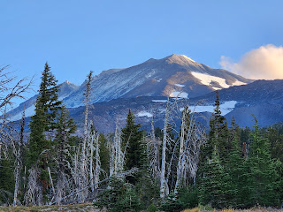
 |
| Early morning view of Adams |
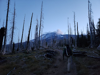
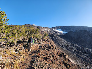
We left Cold Spring at 6:30 at the very nice trailhead. This area was part of a forest fire in the last 5-10 years and so the sight lines are wide open which was kinda nice for us first thing in the morning. We could immediately see the upper mountain as well as distant peaks like Mt. St. Helens. For the ascent today we were carrying crampons and ice ax as well as most of our standard mountain gear and essentials. We dressed about as warmly as we would for a winter ascent making use of layers in every way possible. I carried just over 3 Liters of water and the filter to be ready for anything the day would offer.
 |
| Good trail through the burn area |
 |
| Mt. St. Helens in the distance |
The first 2-miles are essentially up an old double track road. It was easy hiking and good for making time. We encountered one junction with an Around-the-Mountain trail. We also found a spot with a massive cairn off the left side of the road but no clear route leading from it. It was also here I realized that the GPX track I had taken from the internet might not be completely accurate or might have been a winter or spring route with more snow. We opted to follow the clear trail/road as long as possible and thankfully it was also matching up with the South Climb trail that the Accuterra map on my phone app was showing.
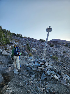 |
"Best route varies with
conditions" sign |
The road trail did finally end at another large cairn with a clear route following. Much like we had encountered on Mt St. Helens yesterday, the route began to follow tall navigation poles with some pretty decent trail segments in between. We followed this up to a narrow traversing switchback section which put us onto a ridge crest. The trail on the ridge gained sharply following more poles and eventually led us up to the first of many small campsites in the rocks. I would in my own mind describe the next 1500 feet of climbing from here as "Campsite Alley" as it seemed we were seeing them in the rocks quite regularly.
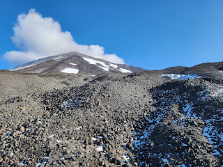
There were good and clear trail segments til perhaps around 8100 which is just above the Crescent Glacier on the maps. I'm not so sure we ever saw the glacier or not. Many guidebooks will mention the route being less clear after this point. I would describe it as "braided". Lots of trail segments but never clear which ones to follow. We moved through this up to the Lunch Counter area and continued to follow segments leading to the large slope up to Pikers Peak and Adams.
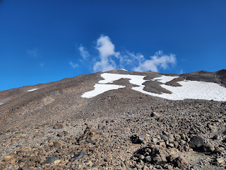 |
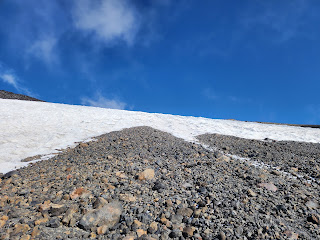
Looking at snow on the slope
above Lunch Counter |
 |
| Looking down the snow chute |
As we ascended this slope we began eyeing the snowfields still remnant on it. We knew this was an area, even here in September, we might still encounter snow. It was possible to bypass the snowfields on climber's left but we weren't sure how far out of the way this would take us. About halfway up the slope the snowfield on the left had a break in it and we saw this as another place to bypass. At the top of the slope in the middle we could see what appeared an obvious chute where most climbers would ascend through the snow. It looked fairly steep from below but we figured it would also be an option. As we climbed up the slope we finally decided on going for the snow chute. We followed faint trail segments up to it on what I would call mostly easy class 2+ terrain.
 |
| Rocks on the saddle before Pikers Peak |
The chute was just steep enough with snow just icy enough that we decided to put on the crampons we had carried. We figured we had carried them this far might as well use them. We figure microspikes could also have gotten the job done here for traction. The snow above was also heavily snow-cupped making it look like a massive slope of moguls from a ski resort. We climbed up the snow chute and found the snow extended another couple hundred feet as slightly less steep terrain.
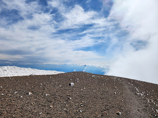
When the snow ended we took off our gear and got ready for some more small rock and trail segments. The climbing continued up to a nice saddle at around 11500. The clouds began to settle in around us blinding out the summit and the winds picked up. The temps were low enough the rows had some obvious wind-blown frost on them. We were worried about being in a white-out again on the upper mountain as we were yesterday. We wanted some views this time!
 |
| Easy snow guarding the final saddle before the summit push |
 |
| Good trail in the last couple hundred feet |
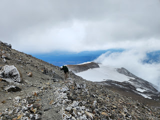
The terrain up here was easy to pass and mellowed out with good trail heading over to the final ascent up Adams. There was another saddle before this final ascent. The winds really were rocking here. It was another to nearly knock us over. On the plus side we got some amazing looks at the glaciers on the east side of the mountain. With the winds the clouds also were shifting and moving giving us the occasional bits of blue sky. We could also see some clear trail leading up the last 900 feet giving us a clear direction to move.
 |
| Wooden shelter building on the summit plateau |
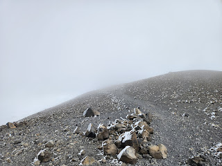
The trail was clear the remaining distance but it was a battle on every switchback with the winds trying to knock us over. We really had to lean into every step and use our trekking poles as assist. As we neared the summit we were surprised by the sudden smell of sulphur in the area. We saw plenty of yellowish rocks which appeared to the source. The views began to disappear with the clouds again. We walked past an old wooden building on the summit and turned to the northeast for the final tenth of a mile to the true summit. It was cold and we were wearing every layer we had. We tried to hang out up top and wait for views but they remained minimal. If we took gloves off our hands to handle our phones our fingers would go numb fairly quick.
 |
| Adams summit |
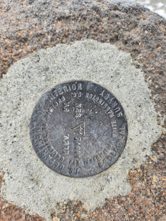 |
| USGS summit marker |
We spent 15 or so minutes trying to enjoy what we could. Right as we began our descent I looked to the north and saw a fleeting glimpse of Rainier. The clouds were shiftly rapidly and literally gave us about 5 seconds. Well before I could get my camera app open the view was gone. We stuck around another 10 minutes shivering in the cold hoping for the view to return but it never really did. Thankfully as we picked up our movement on the descent our bodies warmed quickly.
 |
| Frosted rocks on the summit |
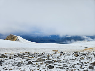 |
| Modest views to the north |
The descent of the upper mountain went without problem and we reveled in the amazing views of the glaciers once again. When we returned to the snowfield on the slope above lunch counter we went with crampons once again. We ended up descending not only our ascent route but we followed the snowfield on the east side all the way down to 9600. It turned out to be fairly easy in terms of steepness. The primary challenge was dodging the ups and downs of the heavily cupped snow.
 |
Back to the saddle before the final summit push
Cool crevassed glacier in the background |
 |
| Descending past Pikers Peak |
The remaining descent past Lunch Counter went well. We had a surprise site down in the rocks where we saw a small fountain of water coming out of the ground. It was a stream shooting about 3 feet into the air. There must have been enough pressure of water coming out of icy snow to push the liquid out a hole up into the air.
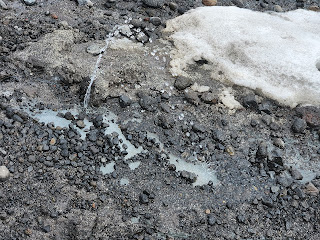 |
| The fountain |
We made it back to the trailhead at 5pm after a full day. We were quite glad to have made the start/stop from Cold Spring and not be hiking another 3 miles or so down the road.
 |
| The "best route varies" signs just made us chuckle |
Track:
I have a track and waypoints from the activity all contained in the embedded Google Map. Check it out and use at your own risk.

 To climb a volcano in Washington state is quite an endeavor. Most people from out of state generally only know about Mount Rainier as the big mountain climb. Many others are aware of Mt. St. Helens but few think of it as a mountain climb and rather a tourist destination. Mount Adams exists in the middle of it all with little outside attention. Its the 2nd highest peak in the state and from afar looks every bit as imposing as Rainier. It has sides that are glaciated like any of the other big volcanoes in the state. It has a massive prominence that adds to its grandeur. But it also has something that some of the other big mountains do not: a non-technical approach.


.jpg)


No comments:
Post a Comment