Table of Contents
Planning the Itinerary
Training
Packing
Friday, Sept. 18
Saturday, Sept. 19
Sunday, Sept. 20
Wrap-up
Most Americans are familiar with the Grand Tetons. We've seen the pictures from various vantage points of this jagged row of unmistakable peaks. They are undoubtedly a source of immense beauty. To visit the park ups the ante. Opportunities abound to see unique wildlife, at reasonable distances of course. There are ample trails and wonderful campgrounds to get one up close and person to nature and to this beautiful National Park.
The next step is to get into the backcountry. Its one thing to see the Tetons from their typical side on the east. Its another to hike around to their backside and to take in all new views of these majestic peaks. Not too many tourists into the National Park get further than a mile from the trailhead. To adventure deep into the backcountry, into the territory of grizzly bears and moose is where my brother wanted to head. We're no strangers to this kind of place and we've now long had a love for it.
 As a follow-up to our memorable 2017 double crossing of the Grand Canyon we decided it was time for another big adventure. A place to enjoy a National Park, see some wildlife, and tally up a big number on miles was what we were looking for. We decided on the Teton Crest Trail.
Most users will read about a 39-mile version of the Teton Crest Trail. This would start at the Granite Canyon Trailhead, follow the Crest north through Paintbrush Divide, and then descend down to the String Lake Trailhead. There are a number of variations to this route. Some will start at the very south end of the Teton Range at what I believed is called Philips Pass. Most will start either at Granite Canyon or in Teton Village. Those starting in the Village will ride the Tram to knock out the initial elevation and then hike down the Rendezvous Mountain trail to get to the Teton Crest trail.
We decided on what we felt would be a more elegant loop of the whole range. We also opted for a method which would cut out the middle man. We only had a single vehicle and in the era of COVID-19 didn't wish to hitchhike or figure out extra transportation. Plus, it seemed a bit more epic to complete the whole loop in one push. Our goal was to both start and stop at the same location while hitting the traditional Teton Crest Trail. We would start from Jenny Lake and hike the east side of the range before eventually hiking up the Granite Canyon trail to join the usual path. We figured this would add up to at least 53 miles in total. It would be on par with our 2017 Grand Canyon adventure and offer up all new and exciting challenges.
PLANNING THE ITINERARY
While there can be many challenges to planning a backcountry hike through Grand Teton National Park we kept things about as simple as can be. There is a window from January to May where permits can be reserved ahead of time for an itinerary and the various camping zones. We debated this back and forth and opted to forgo that option of obtaining a permit ahead of time. Part of it was to keep our flexibility. Part of it was we had confidence in our original itinerary of doing this in two days and camping in Alaska Basin which is outside the park and doesn't require a permit. When COVID-19 hit the world we were even more glad we hadn't locked into a permit and retained all of our options for how to handle the trip.
I spent months researching various alternatives and bail-out plans for our hiking itinerary so I could feel as though we had considered all the options for pulling this off and in a safe and manageable manner. Could we really do the roughly 53 miles in two days? We had done that in the Grand Canyon, could we do it again here? Would it be harder? Easier? What options existed to possibly shorten? As the trip neared its date we really began to plan various possibilities of what to do with our extra day. We planned to hike the TCT on and Sunday, but we also had Friday wide open to handle logistics and sightsee. When the trip arrived and we were on the drive from Salt Lake up to Jackson Hole on Thursday night we resolved to attempt to break things into three days. If there were walk-in permits available for a camp zone that would help us we would use it. We kinda felt like all options were on the table. We knew we wanted to do the whole loop but we could change directions and starting points to figure out a way to make it work. We also were factoring in the weather report calling for rain all day on Saturday. Talk about a juggling act trying to weigh everything in the balance.
TRAINING
In recent years I've been working hard to become somewhat of an amateur ultra-runner. I've completed three ultras now one of which was the 50-mile version of Run Rabbit Run. I loved it. I enjoy the challenge and the logistics needed to both train for and complete an ultra run. I've been in a big time running mode for many years now. Yet, as I contemplated how to prepare for the nearly 60 miles of our Teton Crest Loop plan I decided not to treat it like an ultra. I continued my running, up to a point, but I tried a different philosophy for this. I emphasized time on the feet. I focused on daily step counts and getting miles on feet whether running or hiking or walking, even biking.
One of the reasons for this change of focus was to combat one of the typical problems of long hikes for me: sore feet. With no need for speed it seemed a good move to simply take the time all summer keeping my legs used to constant motion and my feet ready to handle the steps. The COVID-19 pandemic helped with this providing ample time and opportunity to be outside and socially distance on my feet on sidewalks and in woods.
In retrospect I would say this strategy seemed mostly successful. My legs were absolutely in great shape for the hike and felt great through all the miles. My feet however still struggled the last 6 miles or so of the descent from Paintbrush Divide. I had a blister form on my left foot in a spot I've seen it before. I've also been dealing with a light case of plantar fasciitis in my right heel which acted up some on the hike. These ailments made things uncomfortable but they weren't debilitating. Its also possible that hiking 24 miles on our third day the latter half of which was 4000+ feet of downhill might have made any feet sore.
WHAT WE PACKED
My brother and I feel like we're starting to really honing in our light and fast version of backpacking. We're not quite fastpacking like many ultra-runners do, but we are going much lighter than regular backpacking. We are using daypacks to handle two nights of backpacking and going light as can be. I had debated between an Osprey Volt 60 pack and my REI Lookout 40 pack for this trip. I really wanted the lighter pack but had concerns about fitting everything. The kicker for me was if my brother's pack would fit the bear canister. It did. On my pack I was able to strap tent and sleeping bag to the outside and fit everything else inside. We kept clothes to a minimum. Though with the last minute weather reports of a Saturday storm and near freezing overnight lows we did end up adding an extra thermal layer for the trip.
Here's a basic packlist:
- Tent: REI Quarter Dome 2
- Sleeping Bag: REI Flash Ultralight Bag
- Pad: NeoAir XTherm Pad
- Filter: Sawyer MicroSqueeze
- Clothes:
- Wore zip-off pants and a long-sleeve tech shirt
- Packed long underwear top/bottom and a fleece top, a gore-tex light jacket, light gloves, extra socks and underwear, hat, winter cap
- Hydration: 1.5L bladder, Gatorade bottle (for Tailwind refilling)
- Emergency: SOL Emergency Bivvy, Matches, Swiss army knife, Garmin inReach Mini
- Cooking: no cooking gear, just a bear canister with food
- A few more miscellaneous small items
My brother came up with the bright idea of leaving cooking gear behind. This saved us from bringing a pot, stove, and fuel. Instead we tried to get creative with a few food items we could take and eat in the evenings to help the taste palette. The chicken-of-the-sea salmon packets (typically used on salads at home) was a real hit. We did miss having the stove to make hot drinks however, that's a big miss.
For hydration, the Sawyer Squeeze was great. Its quick and easy and made water fillups at the many streams completely headache-less. We made it a point to carry no more than 2 Liters at any time to keep weight down and this worked wonderful. The Tetons were full of water opportunities. I had a system of carrying 1 Liter of water in the hydration bladder and 1 Liter of water in the Gatorade bottle. I put would Tailwind mix in the Gatorade bottle for liquid calories and flavor.
Knowing the weather forecast would put overnight lows in the 30s we made the decision to pack an extra top layer of clothes. I had figured on using a long-sleeve tech shirt and also have a goretex jacket for use during the day. At night I would have long underwear tops and bottoms to sleep in. That gave me 3 total layers for the top. I made the choice to add in a light fleece sweatshirt to ensure I would have adequate to layers for warmth. We were also using good sleeping gear for overnight warmth. I had a 30 degree down bag and the aforementioned NeoAir XTherm pad with a very high R-value. My brother was sporting a brand new 0-degree bag. We felt these items would serve us well. I was also testing out a new idea, at least for me, of keeping my feet warmer over night. Any extra clothes I wasn't actively wearing would get stuffed into the foot box of my sleeping bag. This would cut down on the open air spaces in there where cooler air could linger. Looking back in hindsight I would say this worked.
Friday, September 18
Multi-use trail to Taggart Lake Trail to Valley Trail to Granite Canyon Trail
Trailhead Elevation: 3,923 ft.
Distance: 17.47 mi.
Elevation Gain: 2163 ft.
Elevation Loss: 1646 ft.
Start Time: 10:45am
End Time: 4:59pm
Trip Report:With our newly gained permits to camp in the Lower Granite Canyon Zone we set about to hit the trail. We had plans to start and return to the Jenny Lake parking lot for the whole loop. In our original itinerary we had figured the first 5 miles or so in the valley would be something to be done in the dark and best done first rather than last on the trip. The only improvement upon this plan would have been to start at String Lake. That would have been a great stopping point after the long descent from Paintbrush Divide. Putting those 3 miles from String Lake to Jenny Lake at the beginning would have helped on the 3rd day.
 |
Cruising on the multi-use trail in front of the Teton Range
|
We set out on the multi-use paved trail and we made really quick time. We were pushing over 3.5 mph on that hard pavement. It was probably also a bad decision. Making time is one thing. Hitting hard pavement with an extra 25 lbs on the back is nearly punishing. We could sense an added soreness in the feet as the day progressed because of this start.
 |
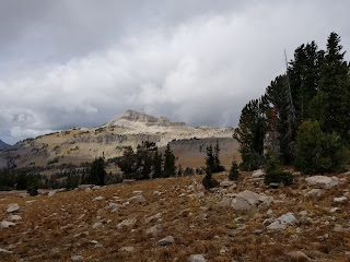
Beautiful view of the Tetons, wish for less smoke haze and clouds
|
We had debated whether to use the valley trail out of Jenny Lake or this multi-use trail. The multi-use trail would be faster and "easy" miles to start the long trip. The Valley Trail would be trail. The multi-use would also have the better views being out in the open instead of the trees.
 |
Small waterfall on the hike up to Taggart Lake
|
 |
Taggart Lake
|
When we hit the Taggart Lake trailhead we debated whether to take the shortcut to the south side of the lakes, or to take the main trail to the lakes to see them. We opted to see the Lake. We knew we had plenty of time today to add an extra mile and some elevation and figured it was worth it to see the Lake. It was quite crowded with people but we were glad to make the hike up. The Lake was quite pretty and reminded us of a bigger version of Harvard Lakes which we saw in Colorado this summer.
 |
Cruising along the Valley Trail
|
We left Taggart Lake heading south on the Valley Trail and suddenly we were away from people. This would pretty much be the case the rest of the day except for Phelps Overlook. This section of trail was very peaceful as single-track in the woods. There wasn't much for views because of the proximity now to the mountain slopes.
 |
Phelps Lake
|
With this new found solitude on the Valley Trail we finally had a moment to really begin to take to heart what it meant to be in grizzly country. I had certainly done my fair share of reading and preparation on how to be prepared for this. We took the strongly advised measure of buying a can of bear spray. Though there were two of us we did make the decision to only bring one can. Alongside that decision we would be intentional in never separating from one another. The other active measure most hikers take in bear country is to be "noisy". I put that in quotes as there is a good etiquette way to do this and a bad. The bad would be to be blaring loud music during your hike. This would serve to alert the bears to your presence. It will also make fellow hikers annoyed and probably scare all wildlife away from your view. The good etiquette way is to keep up good normal conversation. The human voice carries well enough on its own and the bears will use it to distinguish you from a deer or an elk. With that in mind, we did intentionally seek to keep the conversation going, especially in areas of thicker vegetation or areas we felt it likely we could stumble upon a bear.
Phelps Overlook was the next highlight as we reached this opening looking down upon a large lake. We were surprised how far below the lake was, we weren't expecting to be so high still. We ran into a handful of people here taking breaks and we did as well. We were still in cell signal so we made a few last communications before we expected to go into blackout for the next 48 hours.
The descent to Phelps Lake drops over 500 feet to a trail junction for the handful of campsites. It then makes a quick climb back up to nearly the same elevation. For us it was rather unfortunate to lose and then gain all that elevation. Another couple of miles in the woods to ourselves until we hit the next junction with the Granite Canyon trail. The junction is a mile and a half or so up from the Granite Canyon trailhead but we ran into a number of dayhiking groups enjoying this trail.
As we moved into Granite Canyon we made our one and only water stop of today's hike. I pulled out my Sawyer Squeeze and we got a liter into both mine and my brother's water supplies. We did this right around the beginning of the Lower Granite camping zone. From here on out we were on the hunt for the right camping spot.
 |
Looking up Death Canyon
|
We were a little after 4pm at this point and the legs still felt good so we figured we could keep shaving off more miles today and leave less for tomorrow. So we passed the first couple of designated spots. We pretty much didn't see any great spots for dispersed camping so that was practically out. It was either the 4th or the 5th designated spot that we finally stopped at. We have a waypoint for it on the map at the end. It was up on the hillside just a bit from the trail and nearly out of view. It had just enough of a flat spot to pitch my Quarter Dome 2 tent.
Its worth sharing at this point that at some time during today's hike we had the realization that the lovely permit we had paid $35 for this morning got left in the rental car. I knew exactly where it was sitting and somehow it just didn't make my mental checklist in our haste to get going. Ultimately there wasn't much we could do but shrug it off. We hoped we wouldn't run into a ranger and have to explain. We doubly hoped if we did see a ranger that our explanation and honesty would win the day. It dawned on us we had the e-mail receipts from Recreation.gov for the permit but weren't sure if that would be enough either. Thankfully, we never had to test our abilities to talk our way out of the situation. We had done all the right things to camp legally ... except for forgetting the permit back at the car.
 |
Just a beautiful walk in the woods
|
Our surprise for the evening at camp was that we were getting about 2 bars of Verizon 4G LTE. It was enough to do a little bit of communication and grab a few headlines. It was here we found out that Supreme Court justice Ruth Bader Ginsburg had passed away.
We took a relaxing evening with all the time we had. For supper I ate a ham and turkey sandwich I had picked up at the Jenny Lake camp store along with some other small snacks. The weather was good to us and while it cooled come dark it never got bitterly cold over the night. When it got dark near 8pm we finally settled into the tent and read some eBooks on our phones til we were ready to fall asleep.
 |
Colors starting in Granite Canyon
|
Saturday, September 19
Granite Canyon Trail to Teton Crest Trail to Alaska Basin
Start Elevation: 7,299 ft.
High Point Elevation: 9,837 ft. (Alaska Basin)
Distance: 16.22 mi.
Elevation Gain: 3,719 ft.
Elevation Loss: 1,357 ft.
Start Time: 7:41am
End Time: 3:34pm
Trip Report:
Today began with much uncertainty. We had been closely following the weather reports that said it could possibly rain the entire day. There was some hope it all might stop by 6pm but we were prepared to be wet today. We were awake in the dark just after 6am and thankfully we didn't hear any rain coming down yet. We were also surprised that it wasn't all that cold. My tempe sensor said 58 degrees though we thought that might be slightly inflated. At first light we hopped out of the tent and were pleased to find it completely dry still. We set about getting the tent taken down quickly to keep it dry. We readied our packs with covers and made sure we could handle the rains when they would come. |
Morning in Granite Canyon
|
We weren't on the trail too long before the rain began. It was a light drizzle at first and then became a steady drizzle. It never turned into a downpour but it was a steady shower and enough to begin to get us wet and a little chilled. My old REI Elements Jacket was clearly no longer up to the task. Twice we stopped in groves of trees for a quick reprieve from the rain. The latter we stayed 25 minutes just waiting to see what would happen.
Today was an odd day in terms of time management. We had done the math on our mileage and speed and concluded it was likely we would hit camp between 3 and 4pm. That felt like a bad thing given the weather. We didn't want to hit camp too early and end up standing out in the rain unable to setup a tent. So we intentionally tried to slow up and take time. Thus we had every motivation to wait in the dryness of the trees as it rained. What ran counter to these intentions was the breezes and cool temps that had come. The longer we stood in place the more cold we got. This inevitably gave us motivation to get moving on the trail again.
 |
An ominous weather day
|
Much to our delight, as we made our way higher into Granite Canyon the shower eventually lightened up and then stopped. By the time we hit the junction for the Teton Crest trail it had pretty much stopped falling entirely. The cloud cover was still present so we remained ready for it to start up again but to our surprise it didn't. When we reached Marion Lake we ran into several other groups camping in the area. This certainly seemed like one popular place to backcountry camp. Quite a few camp sites were in the area near the lake. On any other day this would likely have been a gorgeous place.
 |
Coming up on the usually gorgeous Marion Lake
|
After the lake was a quick climb up to the Fox Creek Pass area. It was open and expansive and we could only wonder what it would have looked like a few weeks prior with wildflowers still filling the area. We could see much of the plant life with a matted down look from the snow storm 10 days prior that put six inches up here. We felt like we may have just missed some of that beauty. On the other hand, we knew that being up there in September meant great hiking temperatures and a completely lacking of nasty mosquitos and other bugs. And indeed, that held true, not a single mosquito the entire trip. Through the Fox Creek Pass area we had views of Spearhead Peak just to our east. It was a double-headed mountain with a jagged pointy summit and a rounded rock pile of a summit. I knew from maps there was an easy trail heading to the rounded summit. If we had more time this may have been a worthy hike to see the views from above.
 |
About 2 weeks too late for peak
wildflower season at Fox Creek Pass |
After Fox Creek Pass came one of the most unique areas of the whole Teton Crest Trail: Death Canyon Shelf. We had the impression this was one of the more popular backcountry targets and we could see why. Generally the "shelf" was about 50-100 yards wide but it does begin to cliff out on the east side if you get over. The trail never reaches anywhere near the edge however. There were mixed pockets of trees all throughout the shelf and we could see where there would be some nice camp spots. We had heard there was water to be found on the shelf. In September this was barely true. I recall one, maybe two sports and both seemed closer to the north end of the shelf. The views really became amazing when we began to see out the whole of Death Canyon to the east. This is an odd canyon with a bit of an L shape and would make for a beautiful hike. We were also aware through here that if the skies were clearer we would be having some great views of the Tetons out to the northeast. Alas, today was not to be the day for big views like that.
 |
Death Canyon Shelf is really something unique
|
 |
Death Canyon
|
As we passed noon we were delighted that the rains continued to be held at bay. We were beginning to dry up and shedding rain jackets and other layers. We began to get some confidence that the weather could hold out all afternoon and allow us to get a nice camp setup in Alaska Basin. With this added motivation of the weather holding together we kept our pace moving along. We had talked of taking a 30 minute break on the Shelf for lunch but ended up just cruising along.
At some point today it dawned upon us, this was our first true backcountry day together in many years. By "backcountry day" we mean a day in which the whole 24 hours are spent away from civilization in the backcountry. By necessity, this would need to be a day in the middle of a backpacking trip. For us, it has been a much rarer type of day than you'd think. We'd done so many backcountry nights on the 14ers but it was always only one night out. We hadn't strung together a series of nights in the backcountry since 2004! I've had a couple of trips in recent years that hit this. In 2017 on the Zion Traverse trip with a couple of buddies, and then in 2016 on Isle Royale with my father and sons. But with my brother, it had been 16 years since our Comanche-Venable loop in the Sangre de Cristo Range in Colorado. Hard to believe it had been that long.
Up to this point, with a day and a half of hiking under my belt I felt our nutrition strategy was really working. My energy continued at a consistently high level and my legs felt good. After hitting 17 miles yesterday there was no latent soreness and just a small amount of fatigue which was only felt on the steeper uphills. I was looking to eat in the range of 200 calories an hour while hiking while also saving another 600-800 for camp tonight to put in a good supper. This totaled to around 3000 for this 16 mile day.
 |
Coming up on Alaska Basin
|
We entered Alaska Basin via Mt. Meek Pass. There was good signage explaining the end of the National Park and the beginning of National Forest ground here. This meant no permit restrictions and dispersed camping was allowed anywhere within USFS guidelines. I had done some extensive looking on the maps trying to understand where we might want to stop in Alaska Basin to setup camp. Our original itinerary, had we started at Jenny Lake and arrived here in a single-day push would have had us camping early in the Basin, likely near the first lakes. Given our updated itinerary of knocking out miles yesterday, now we were interested in moving as far across the five miles of Alaska Basin as we could to make tomorrow's mileage smaller. We decided to target the Sunset Lake area, possibly higher, depending upon what we saw.
 |
The elusive black marmot of Alaska Basin
|
The initial push into Alaska Basin was across a plateau with a few small ups and downs. This lead into the Sheep steps which were a quick series of switchbacks through a rock band to drop into the Basin proper. The trail itself never got very steep here but it did narrow up with some modest exposure to the side. It was an interesting area to behold the trail work. We began staring across Alaska Basin trying to figure out where the trail would head next. I had seen it so many times on satellite maps yet it still wasn't entirely clear when we stood here in person.
 |
Heading down the Sheep Steps into Alaska Basin
|
We were intrigued to see how much the Basin dropped elevation and were concerned the trail would also follow that loss and then the subsequent gain. So much to our pleasure did we find that the trail really contours around to the east in the basin only dropping a small amount of elevation. Its a great design making for a good trail and good hike. As the trail neared the lakes there were a couple of sections that moved through flat rock slabs. We nearly lost the trail in the first one. We finally saw straight lines of rocks ahead that signaled the trail passing between them. A keen eye was needed to keep track of the trail. We did not end up seeing all of the Alaska Basin lakes as some were hidden from view on the trail. There was undoubtedly plenty of great camping in here.
 |
The rock slabs of Alaska Basin
|
 |
Another black marmot in Alaska Basin
|
At a small grassy flat that looked like it could be marshy in the spring and summer, the trail began its turn to the west and gained ground out of the lower Basin. With a couple of switchbacks it gained upwards to another rock band where several very narrow switchbacks moved up above the rock band. We kept expecting to crest out and see the lake ahead but the trail continued its northwest trajectory. This area took longer than expected but we were glad with every mile we got under our belts today. We were also thankful how well the weather had held this afternoon.
 |
The aptly named Battleship Mountain
|
The high elevation of the day came just before the descent began down to Sunset Lake. Though today's weather and lighting limited the colors, we could see this would normally be an absolutely wonderful area to spend time. We could see at least two groups were already setup in the vicinity of the lake to camp. More still to come. The trail wrapped around to the west side of the lake where we talked to a gal who was pointing out where some of the camping was. We were eyeing a grove of trees on the north side of the lake up on a small hill. We liked the location and we liked how it was on the path of the trail heading out of the Basin ever so slightly shortening the morning's hike. We were even looking at campsites further beyond the Lake to see if any would make sense. We had even for a moment discussed trying to head up towards Hurricane Pass. However, the exposure to the weather these locations would have ultimately turned us away. And given the evening's storm we were abundantly glad we had made the right choice.
In scouting out the groves of trees just north of the lake we settled upon a site with just enough flat area for the tent. We also chose it for just a bit of tree cover from wind and rain. This would prove very beneficial. Once we had the tent set up we really settled in for a bit. It was around 4pm as we got things going at camp. It was still a bit early in the day and we knew we had a lot of time ahead of us before dark. We were glad though just to have camp setup before any further weather.
 |
Sunset Lake, our resting place for the night
|
We found a nice slabby rock area near our camp to sit and take our wet shoes and socks off. We sat there downing some good calories and enjoying the beautiful view over the lake. We were 33 miles into our trip at this point and we were feeling great. Today's weather hadn't been as bad as feared. Yea, the views had been diminished but we still enjoyed the natural beauty of everything. After our afternoon snack we headed down to the lake, barely a 5 minute walk, and enjoyed some time down there just taking it all in and enjoying good conversation.
At this point as we were watching the clouds and the weather rolling by and some instinct kicked in. We weren't in an immediate threat, but there were enough darker clouds in the vicinity that we decided to kick in gear plans to get tasks complete and into the tent. Back at camp we got our packs situated and everything into the tent that would be needed. We hit a drainage creek nearby to fill up water for the night and the morning. We also got in our big supper for the night. I had been planning for this one for awhile so I was excited. I had a chicken-of-the-sea salmon packet as well as a soft tortilla with RXBar nut butter spread. It was great. The salmon hit the spot even though it wasn't heated up. It was great to get that real food taste in our bodies. We were pretty content after this meal.
 |
Camp all setup above Sunset Lake
|
 |
Camp after the big storm
|
We seemed to finish up just in time. David had already crawled in the tent and I was taking care of a few final things as we heard a thunder crack and could feel light sprinkles start up. It was about 6:30pm and we could tell we'd be in it for awhile. I got into the tent as the storm kicked up. Just in time!
We now had a decision ahead of us. It was at least 90 minutes til dark and over 2 hours from when we could conceivably wish to go to sleep. What to do? Well I had a couple of movies on my smartphone and we settled on a nice Vietnam movie called "The Last Full Measure". We had to pause it a couple of times when the winds or the thunder would really kick up. As the storm continued we would peek out of the tent to see what was happening and to our surprised saw white. There was graupel covering the ground. We'd seen it in the mountains before and it was still a nice surprise to see tonight. As hard as the winds were howling we were very glad to have found good over for out tent in the grove of trees.
 |
Sunset Lake looking a little frosted now
|
Just before dark we headed out of the tent for a quick bathroom break and to get some photos of the newly whitened landscape. Always amazing how quickly things can change in the mountains. We resolved to get an early start in the morning targeting a 5:15a wakeup and a 6am start in the dark.
 |
Family of marmots in Alaska Basin
|
Sunday, September 20
Teton Crest Trail from Alaska Basin to Paintbrush Divide and down Paintbrush Canyon and out to String Lake TH. String Lake Trail to Jenny Lake Trail.
Sunset Lake Elevation: 9,678 ft.
Hurricane Pass Elevation: 10,543 ft.
Cascade Canyon Jct Elevation: 7,835 ft.
Paintbrush Divide Elevation: 10,668 ft.
Jenny Lake Elevation: 6,792 ft.
Distance: 24.23 mi.
Elevation Gain: 3,963 ft.
Elevation Loss: 6,851 ft.
Start Time: 6:02am
End Time: 4:14pm
Trip Report:
 |
A bleak September morning looking like winter
|
We made it up early as intended for our third and final morning. It was dark, it was cold, but we were ready to hit the trail for a big day. We were curious to see the conditions outside the tent and whether the snow had survived the night. And indeed it had. We set about getting camp taken down and packs made ready. All the movement served well to keep us warm in the near freezing cold.
It was on target at 6am when we hit the trail with headlamps glowing and nothing but darkness around us. We right away began climbing out of the last stretches of Alaska Basin. We hit some switchbacks that gained through a rock band to a flatter stretch that would eventually take us up to Hurricane Pass. All the while we were thankful we hadn't indulged our crazier idea of camping closer to the pass. The exposure to last nights storm and the wind would have been potentially disastrous.
As we neared the pass the morning light started to come up but the cloud cover remained thick. As we gained the pass we had moments of near whiteout as the cloud deck came even lower. After surviving yesterday's weather we had had hopes of a beautifully sunny day today. Unfortunately, the morning wouldn't cooperate. Where we hoped to get epic views of the Tetons from Hurricane Pass the clouds just wouldn't relent. We did have one big positive to enjoy at the pass. I had been enlightened by a backpacking podcast to the existence of bacon jerky and what a delight it is in the back country. Who knew you could actually have bacon for breakfast while in the wilderness? We stood at the pass munching on this tasty treat I had brought along. The taste was good, and we wondered what delight it would be if we had some fire to heat it up as well.
 |
From Hurricane Pass
|
The descent from the pass moved through some jagged terrain with a nice shelf trail. This brought us into views of Schoolroom Glacier. It had some large crevasses in it and a glacier blue melting pool below it. In fact there were a handful of small glaciers in view here on the west side of the Tetons. We would quickly learn Cascade Canyon is another of the most beautiful and desired locations in the Grand Teton back country. So many fantastic spots to camp with views. Add in the waterfalls and nearby glaciers and you've got a winner. We were sure we'd get a wildlife sighting in through here but we would come away disappointed on that front. The trail does a meandering descent through the upper portion of the South Fork of Cascade and then eventually enters thicker trees as it heads down towards the Junction.
 |
Praying for the Tetons to spring forth from the clouds
|
 |
Schoolroom Glacier
|
 |
Descending into South Fork Cascade Canyon
|
 |
Pool at the base of Schoolroom Glacier
 | Can only imagine the beauty here in spring
|
|
 |
Looking up to Avalanche Divide
|
We took a brief break at the Junction where one can choose between South Fork, North Fork and the Lower Cascade Canyon trails. We met another woman here who was heading up towards North Fork as we were. The weather was cooperating in so far as it wasn't raining on us, and we even had a few moments of sun trying to poke through. As a whole it remained a cloudy day without much for views.
 |
South Fork Cascade Canyon
|
 |
The sun starting to add some beauty here
|
The early North Fork trail was in thick tree cover and we hoped this wouldn't be the case the whole way. Indeed we were pleased when it opened up to some beautiful views of the canyon ahead. We were also treated to nice views behind, though they would have been even better if the Teton summits came out of the clouds. Once more we figured there were ample places to spot wildlife in the North Fork area but none was to be seen. The trail ascended fairly close to the creek and we even stopped at a nice bridge to do a water fill-up.
 |
Starting up the North Fork of Cascade Canyon
|
As we moved deeper into the North Fork Cascade we began to wonder where the trail would ascend to Paintbrush Divide. I had looked on maps but clearly never looked close enough. The western end of this canyon is a fairly unbroken wall and we just couldn't see an exit. Ironically, we looked to the north side of the upper canyon and saw a long traversing trail. We wondered where it went. A check of the map a few minutes later revealed our ignorance. After Lake Solitude the trail does a 180 back to the east and traverses back up out of the canyon. The answer had revealed itself.
Lake Solitude had several signs posting about the no camping regulations due to the desire to rejuvenate the area. We hit thick cloud cover with little sunlight so the colors at the lake weren't popping for us. We could only imagine how beautiful it must have been on another day at another time of the year.
 |
Lake Solitude
|
The weather wasn't raining but it never made us comfortable enough to slow down. Add that thought to our soon ascending to the highest point on the trip and we decided to keep moving as we hit the lake. We began the long traversing ascent up from the lake. It seemed to go forever. As it nears what appears to be the top it makes a big long switchback before running a bit of a ridge. It was in here we began to bump into a handful of different parties descending from the Divide. It was soon the most people we had seen since leaving Taggart Lake on Friday morning.
The winds also were picking up and the temps dropping. Our tempe sensor was registering down to about 40 degrees now. David stopped long enough to throw on some extra layers on top. Me in my stubbornness stuck with my shorts and a single long-sleeve top. Before reaching the top of Paintbrush Divide from the south there was one last flat getting blasted with wind to gain the pass. We bumped into a trail-runner in here and two other parties. One of them we share chances to take photos of one another at the pass.
 |
Looking back down the North Fork of Cascade Canyon
The Tetons would be in view if not for the clouds
|
 |
On the ascent to Paintbrush Divide
|
 |
Paintbrush Divide
|
 |
Looking more like a winter wonderland
than a September day in the mountains
|
 |
To the north from Paintbrush Divide,
a very steep descent
|
 |
It may have been a little windy and cold up there,
Mt. Woodring in the background
|
The descent from Paintbrush Divide to the north is a very narrow and steep passage. Definitely gets into class 2 almost class 2+. Looking at it from a distance you'd be surprised a trail makes it through that terrain. We were glad to be descending and able to see the route more clearly. The steeper difficulties are short-lived however and the trail soon mellowed out. We encountered our one and only snow crossing on a southward switchback. We did it without any traction devices and it was softened reasonably that we could get good footholds in the steps already present.
 |
Can you see the trail in here?
|
We soon moved into the Upper Paintbrush camping zone and had passed another several groups heading up to the Divide including a few more trail-runners. We hit the Holly Lake junction and decided to take the route by the lake. It was our estimation whether going by the Lake or staying on the Paintbrush trail the distances were roughly the same. Below Holly Lake the trail began to move into and out of the trees more frequently.
After Holly Lake we began to succumb to the doldrums of the long hike out. We had been engulfed in the terrain and the views and the challenges all the way up to this point. But now we were facing what amount to miles and more miles. We'll grant that the views out to Leigh Lake were beginning to rise to a stunning level with the sun starting to hit and blue skies popping out. The further we descended though the more the views disappeared and the more we found ourselves in the trees.
 |
Grizzly Bear Lake and Upper Paintbrush Canyon
|
At one point we saw a guy off trail 20 yards and we began to hope there was an animal to be spotted. Our hopes rose thinking perhaps we'd get that elusive moose sighting. Turns out it was a deer that was being photographed. They're beautiful in their own right but also a dime a dozen where we come from.
In Lower Paintbrush the trees thickened and we began what would amount to a forest hike for most of the remaining miles. While we were pleased to know that our legs were still feeling good and our intake of calories had kept us strong from fatigue. Our feet were feeling some real soreness. David was also having IT band issues which we didn't want to aggravate much further. This made the final six miles out to Jenny Lake quite lengthy for the minds.
 |
The lone snow crossing of the trip
|
 |
Descending Upper Paintbrush
|
 |
Holly Lake
|
 |
Things getting pretty here with Leigh Lake in view
|
 |
Fall colors in Paintbrush Canyon
|
When we hit the junction with the String Lake Trail we decided to take the north and eastward course around the lake. We were thinking distances to be similar compared to going the other way around the lake, but we liked the chance of hiking by the trailheads on the east side of the lake. If David's IT band got worse we wanted the option to bail out. We strolled through and the flatter ground was helping enough that we both made the choice to proceed forward.
 |
Leigh Lake outlet to String Lake
|
We had also been curious why there was no connector or bridge on the maps where the two trails on each side of the inlet on the north side of Jenny Lake nearly converge. The maps sure showed it ought to be possible to shortcut through there but they never show a connecting trail piece. What the maps do show is a connector happening about 4/10 of a mile north at the outlet of String Lake. When we were finally in this area on the east side heading for Jenny Lake we did indeed see there was no bridge. However, the lake outlet appeared shallow enough and with some fallen timber debris that a crossing, at least at this time of year, would be rather easy. For us today it was a moot point.
Our great Loop around the Tetons was completed with a hike along the east side of Jenny Lake. Its quite the tourist trail and a hike well worth it. For us it was handled with very sore feet and a burning desire for the trailhead. I don't think we enjoyed the beauty of Jenny Lake and the views of the Teton Range as much as we could have if we had been there with fresher legs. We made it back to the car finally just after 4pm to some great relief to be off our feet.
 |
Jenny Lake with Cascade Canyon behind
|
Trip Totals:
Mileage: 57.92 milesElevation Gain: 9,845 ft.
Hours Spent: 53 hrs, 29 mins
Safe to say, we learned a number of things from this trip. It definitely served the purpose for me personally to feed my hunger at endurance challenges. I loved our 2017 adventure doing the R-R-R in the Grand Canyon. It was exhilarating to tackle the challenge of distance combined with the logistics of backpacking and dealing with nature. This trip offered similar yet also different challenges. We didn't have to deal with any heat in the Tetons, quite the opposite. This time around we carried extra clothes and we had wet weather to handle. We had to be concerned about bears on this trip and were thankful that never became a safety issue.
I also learned that while my brother is as capable as any on endurance challenges he doesn't have quite the same passion for them as I do. We share plenty of passions in common but we differ slightly in this area. We shared a similar goal, along with our father, for 25 years when we were pushing to complete the Colorado 14ers. We were all three in lock step in the latter years of that adventure seeking to see it through together. When that reached its culmination in 2015 we were quickly faced with the question all adventurers face: "What's next?"
For myself, I've answered that question with ultrarunning and backcountry endurance challenges like our Teton Loop. I believe my brother's passion to be closer to the realm of climbing the mountains. He was always our best climbing and the only in our group with legitimate ropes skills and class 5 ability. I'm a novice at best in those areas. He was always the one happy to do the extra scrambling and to be our resident mountain goat on the rocks. This was illustrated to me when we talked about the joy of our 2018 Tenmile Traverse. That trip was the perfect blend of both our passions. The rock difficulties between Peaks Two and Four hit my brother's passion, while the long day and nearly 17 miles of hard work fit me. In the middle we blend together.
What all of that points to is we're not sure where our next adventure will take us. Maybe we'll find another perfect blend of all our passions and the beauty of nature to enjoy together. Its just a matter of time for us to discover what that will be.
Track:
I have a track and waypoints from the hike all contained in the embedded Google Map. Check it out and use at your own risk.

 As a follow-up to our memorable 2017 double crossing of the Grand Canyon we decided it was time for another big adventure. A place to enjoy a National Park, see some wildlife, and tally up a big number on miles was what we were looking for. We decided on the Teton Crest Trail.


.jpg)


You have provided a richly informative article about travel. It is a beneficial article for me and also helpful for those who are searching for this type of blog. Thanks for sharing this information here.
ReplyDeletehow to start tour and travel business online