 |
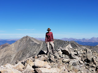
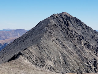
My brother David atop Drift Peak
|
Northwest Ridge from Mayflower Gulch
Trailhead Elevation: 11,512 ft.
Distance: 4.30 mi.
Elevation Gain: 2430 ft.
Start Time: 10:27am
End Time: 2:22pm
Trip Report:
Drift Peak is a little spoken of 13er at the southern end of the Tenmile Range. We looked at it when we were pursing a goal of summiting all the 13ers in the Tenmile Range. We had been close to it several years prior when we were on Fletcher Mountain and recall thinking how close it looked. Little did we know the connecting ridge between the two is quite difficult. Several days prior to our attempt in 2022 on Drift we were again nearby on Wheeler Mountain. It also has a nasty connecting Ridge with Drift. One would think Drift almost unreachable if not for its northwest ridge. This route turns out to be a modest class 2 route that most hikers will find within their reach.
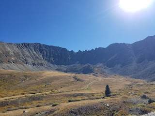 |
| Upper portion of Mayflower Gulch and the connecting ridge from Fletcher to Atlantic |
The NW ridge of Drift is reachable from Mayflower Gulch. One can park in a massive parking lot just off CO91 and only a few miles south of Copper Mountain. If you have a decent 4WD vehicle you can even drive up the road into the gulch 1.5 miles to shave even more miles off the hike. The road is a fairly easy 4WD road with only one crux section which is very rutted up and needed some good clearance. We opted to do the road for our attempt on Drift as we were attempting it one day after a 13 hour affair on La Plata's Ellingwood Ridge and two days after our Tenmile Quintuple which was 13 more miles on the legs. Needless to say we were a bit sore and tired today and looking for an easier effort.
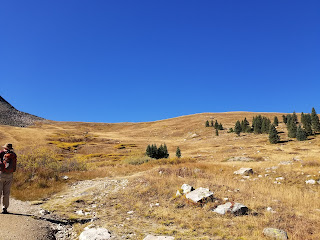 |
| Hiking up the road to the NW ridge proper |
From the end of the 4WD road you actually continue up an old road (now closed off to vehicles) and follow its switchbacks up to the beginning of Drift's NW ridge. This initial road hike is only 0.6 miles and takes you up to 12,000 ft. Its another 0.3 miles of easy, beautiful grassy hiking on the ridge to when the fun starts. Not sure how this happened geologically, but the ridge goes from grass to a massive hump of rocks in an instant. It was like an avalanche of rock suddenly stops all at once.
 |
| The beginning rock hump |
There is a fantastic trail to start this climb up the rock slope and then it seemingly disappeared. We followed faint trail segments to make our way up the rest of it and it was quite steep through this initial climb. The next 0.6 miles of the ridge is scrambling around small humps and various rock obstacles on the ridge but none of it difficult. There are a few small spots where you seem to be near a bit of exposure but it never gets intense.
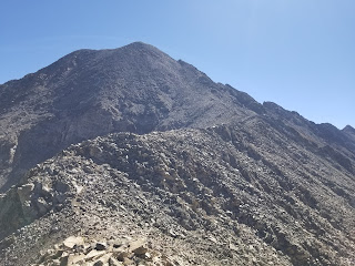 |
| About halfway up the NW ridge to Drift |
 |
A "Crown" shape feature of rocks on Drift's Ridge
(I marked its location on my map below) |
It is the last half mile up to the summit where the grunt really began. Things never got beyond a class 2 rock scramble but it was steep. The last 900 feet are gained in just under a half mile and so it becomes a workout. As we plotted our route from below we wondered if the best route would be to go up the wide scree gully just off the north side of the ridge. As we got into the terrain we found that trail segments seemed to stay on the crest of the ridge and so we continued with it. We sought to stay on the bigger more stable rock where possible to climb as opposed to dealing with steep scree or dirt. At just over 13600 we started to veer to the north and then began climbing into what we figured was the final summit pitch. It got slightly less steep near the summit and the rock was bigger. We topped out in 2:07. This was our "finisher" for the Tenmile Range and we were treated to great views of most of these great peaks from Drift's summit.
 |
From Drift's summit looking over to Atlantic and Pacific
|
 |
From Drift's summit looking to Quandary Peak's west ridge
|
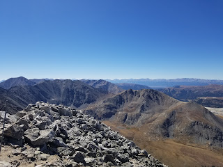 |
Looking west towards the Sawatch
|
360 Photo from the summit of Drift
The descent went well. We carefully worked down through the steep sections up high. When we reached the initial rock slope on the ridge we tried to find any sort of actual trail but in the upper section it just isn't there. Once back to the grass it was smooth sailing the rest of the way.
 |
Descending the steep upper portion of Drift
|
We found quite a few dayhikers in the upper stretches of Mayflower Gulch and there were some mining ruins that were part of the draw. Mayflower Gulch is rightly a popular dayhike area to come up and take in the views and see the mining ruins. It seems not too many take the extra hike up to Drift. Even hiking up to the northwest ridge start is well worth the time and it appeared many will do so and then continue northwest back towards CO91 for a great hike.
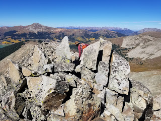 |
| The "crown" on Drift |
Track:
I have a track and waypoints from the activity all contained in the embedded Google Map. Check it out and use at your own risk.


No comments:
Post a Comment