
 Wheeler Mountain
Trailhead Elevation: 10,961 ft.
Wheeler Elevation: 13,690 ft.
Distance: 10.34 mi.
Elevation Gain: 3442 ft.
Start Time: 11:41am
End Time: 6:34pm
Trip Report:
Weather led us to Wheeler. My brother and I had a series of hikes planned out for our trip and a very rainy Thursday September 22 foiled our immediate plans. So we weighed our options. The forecasts did suggest a possible improvement, even clearing, of things by mid afternoon so we explored options with a late start. What we were looking for was a peak where we could stay somewhat low and uncommitted until close to the ending. In part this meant no ridge hikes. We eventually settled on Wheeler as it fit the description of what we were looking for. We've also been eyeing the possibility of finishing all the peaks in the Tenmile Range. In fact our plan for the next days was the quintuple of peaks from Helen to Atlantic. It also appeared the weather forecast up in the Tenmile was somewhat better than down in the Sawatch where our main base was located.
 |
| Montgomery Reservoir |
So we drove on up to the easy to find Montgomery Reservoir trailhead and parked. We had heard a few things about the 4WD road there including one person's trip report who said parts of it made the Lake Como Road in the Sangres look easy. That certainly raised an eyebrow. Right at the trailhead we witnessed a jeep already making its way up the road and moving on to the step of deflating tires to help make the passage.
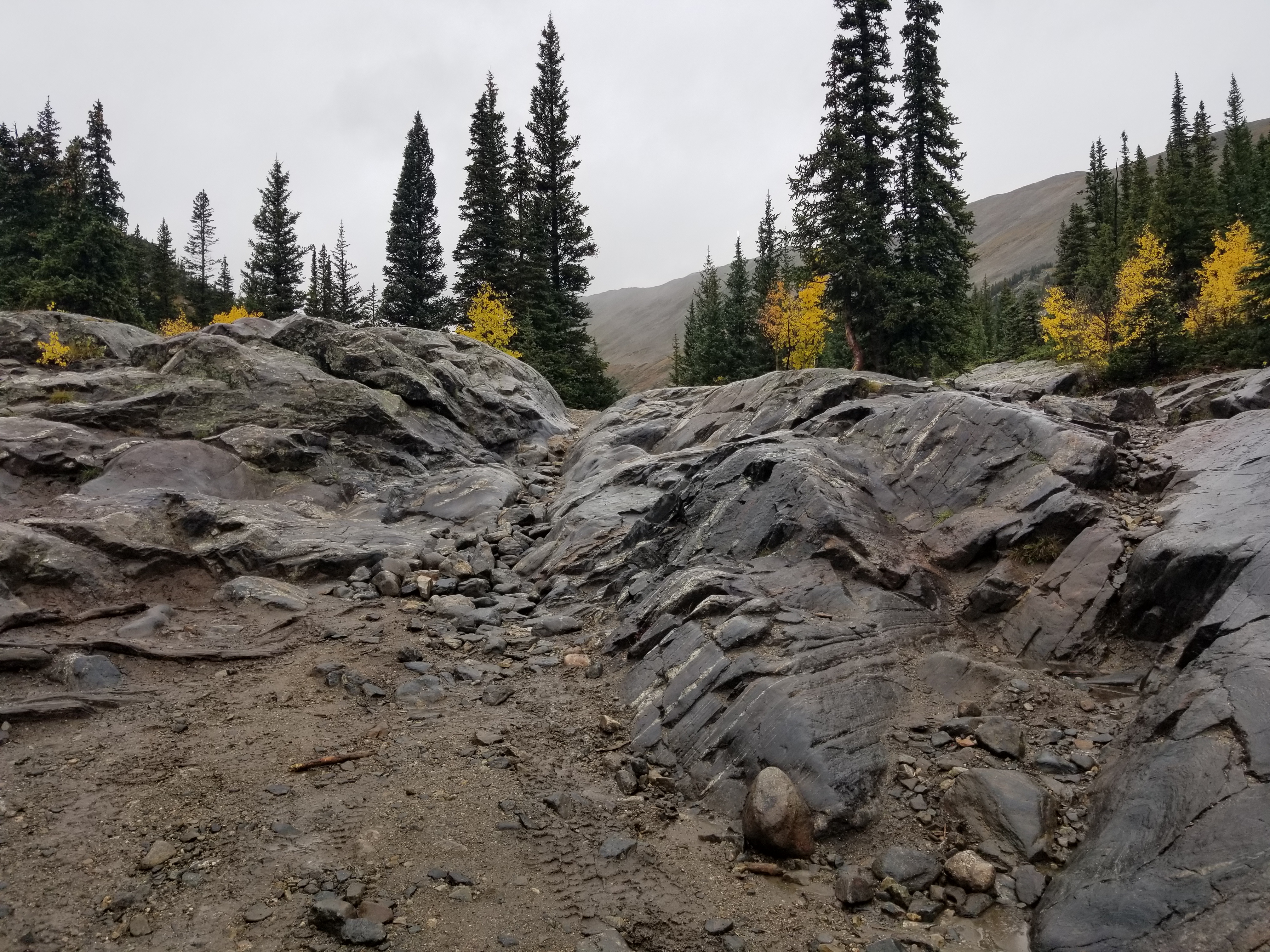
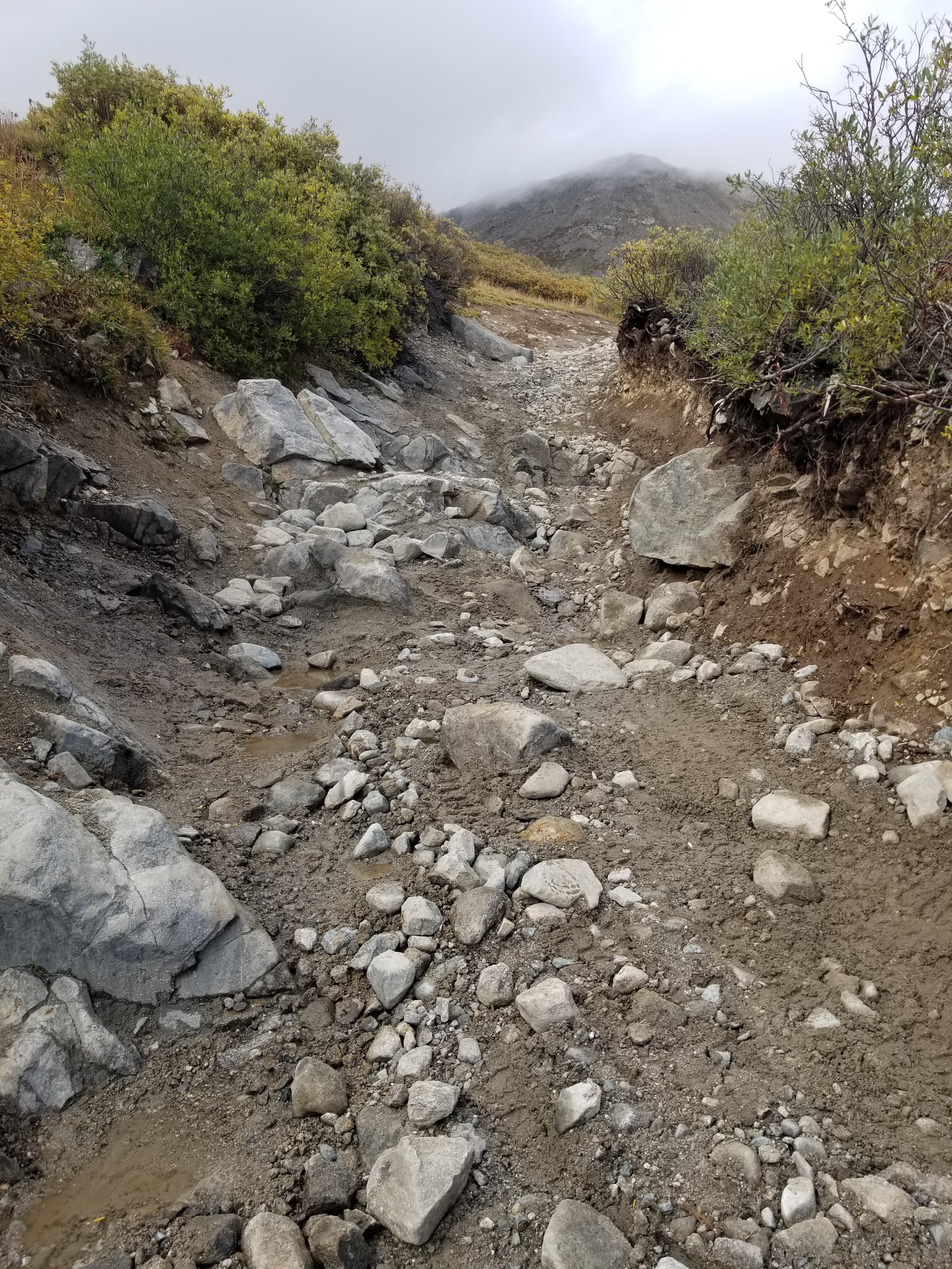
Its worth noting that the first 3.4 miles of this route are all on the 4WD road. The first 2.8 of that are a fairly mellow gain. Along the way you are treated to several incredible solid rock portions for which you can't believe a vehicle would make it through. I would happily be a spectator someday to watch a jeep give it a try. We found the road to be wet and riddled with puddles causing walkers in a half dozen or more places to bypass the road in the brush and trees on the side for short 50 foot sections. This slowed down the pace every time. The latter half of this initial walk on the road is all pretty much above treeline so we were exposed to the weather.
 |
| One of the amazing 4WD sections |
At 2.8 miles in the road takes a steeper and narrow direction up a few switchbacks. It also gets rockier. When we encountered the first big switchback we encountered two jeeps one of which was temporarily stuck. A driver was out of the other jeep giving him directions and helping. It was quite a difficult section of road. We bypassed them and soon made our way up to the end of the road at the lower of the two Wheeler Lakes. It was up in the lakes area we got some drizzle down on us and had donned our rain jackets. We had also been wearing our rain pants the whole way today thinking we were likely to get wet.
 |
| Heading up the road |
 |
| Its quite beautiful in this basin |
 |
| Light snow atop Mt. Lincoln |
 |
| The road gets ever steeper |
 |
| This is where the one jeep was getting stuck |
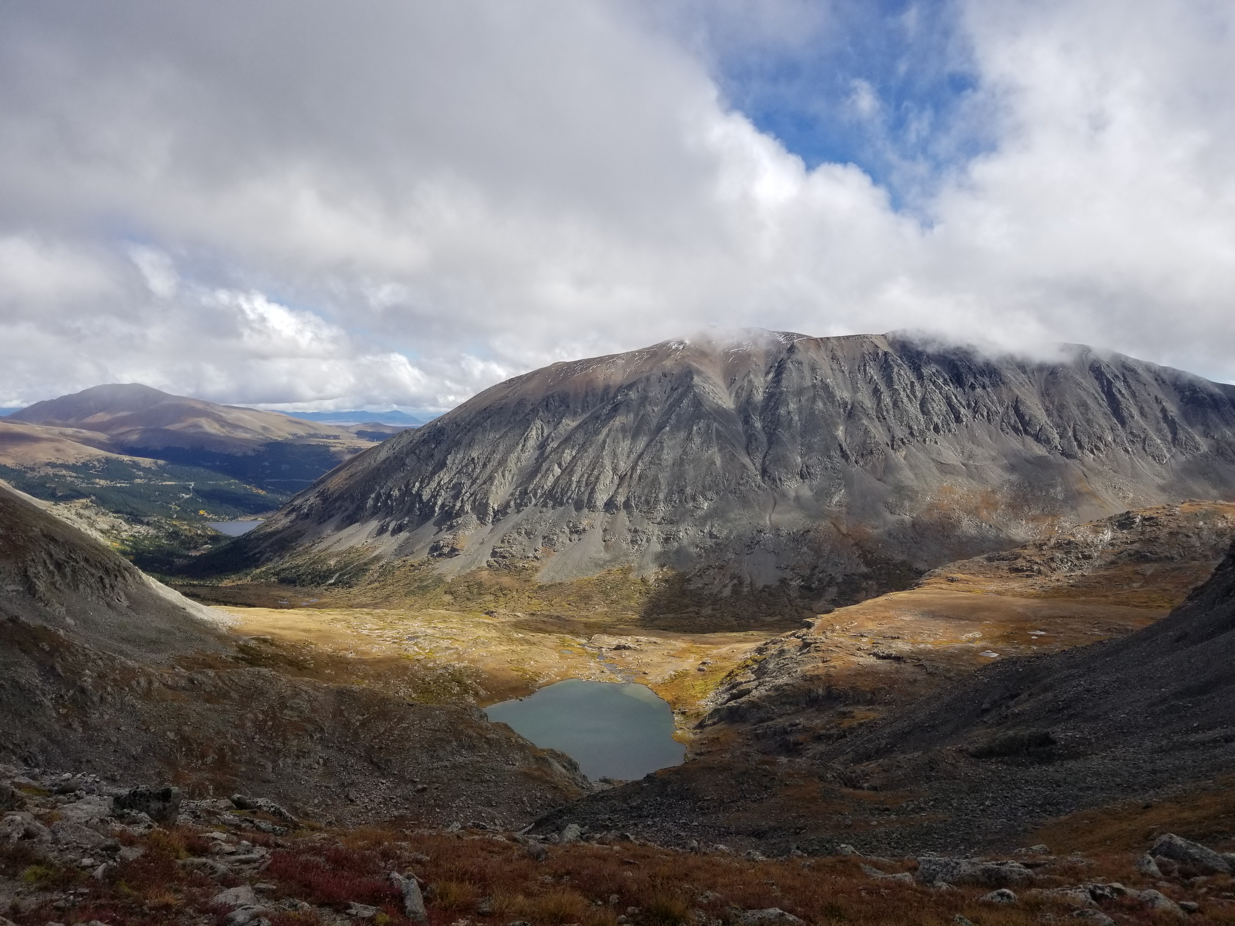
Leaving the lower Wheeler Lake we followed what we thought was a trail up to a rocky section where we lost it. I soon realized looking at the GPS that we were off track. It seems the normal route, if there even is one, took a more direct line and not as high as went.
I'll add this as a note of advice: as we looked upwards it seemed like we could see the ridge top and we, for a split second, debated shooting up through a gully to see if that route would work. Well looking at our track on Google Earth afterwards I can say with certainty it would have been a bad idea. We weren't even close to the ridge and it would have been a mess. So word to the wise: the best route is definitely to head for the upper Wheeler Lake and around the east side.
And that is ultimately what we did. From our high line in the rocks just passed the lower lake we made a beeline for the obvious outlet from the upper lake. We picked up some clear trail again and followed it around the east side of the upper lake. It really is a beautiful area up in the lakes and worth a visit on a dayhike for sure.
As the trail turned west just north of the upper lake it fizzled out again and we bushwhacked for just a bit westward towards the somewhat obvious saddle on Wheeler's south ridge. Around 13000ft on that ascent a thin trail picks up again and guides you on a couple small switchbacks up to the ridge. It was fairly steep in here but still a faint trail to follow.
 |
| Arriving at the saddle |
 |
| Looking back at the lower Wheeler Lake and Mt. Lincoln |
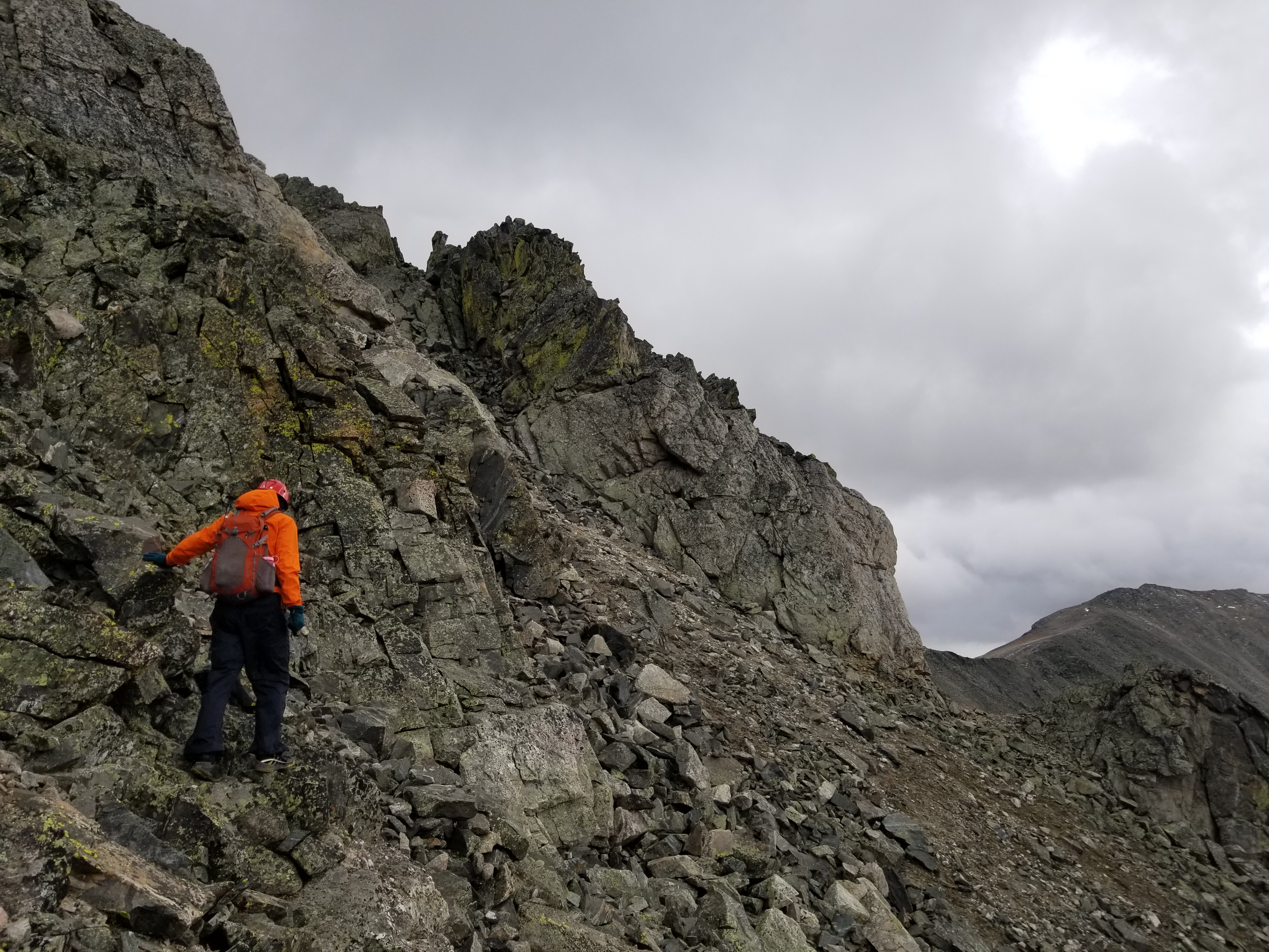
At the saddle, we veered left to the west side of the ridge and began our work. Its difficult to describe every move we made but the gist of it is the south ridge of Wheeler has a number of gullies in quick succession. It reminded us a bit of the upper portions of South Maroon Peak, only on a smaller scale here. We would look for cairns but mostly picked the best lines across each gully on good rock and good ledges. We kept our route to fairly easy class 3.
 |
| Looking across the final gullies on Wheeler towards the summit |
 |
| Looking out Clinton Gulch and the Dam Reservoir |
 |
| My brother David on the summit of Wheeler |
We eventually encountered a wider scree gully and some views towards the summit area of Wheeler. Wheeler has those distinctive white stripes which almost form a "Y" shape near its summit. It was confusing in this area to tell exactly which point was the true summit. We made the choice to ascend the climber's right side of the gully and then traversed across on a line towards what we thought was the summit. After the gully was some moderate rock scrambling to the top. At this first high point we were fairly convinced it wasn't the true summit so we had to descend off it into a notch and then move over to another high point which we were pretty sure was the true summit. We can see why others have encountered similar problems on Wheeler trying to understand the actual highest point.
 |
| Looking from the summit down to the wide scree gully |
 |
| Clinton Peak (13er) |
 |
| Making our way across the gullies back to the saddle |
What thrilled us most was that from the moment we had gained the saddle and onward to the summit the weather had cleared for us. All the while we had resolved ourselves to the possibility that if the weather was bad we would likely not enter the class 3 terrain. Didn't want to be scrambling on wet rock. But the weather cooperated perfectly and we had a great time making the summit and even were treated to some wonderful views. We were especially enamored with the very jagged and difficult connecting ridge between Wheeler and Drift.
 |
| Coming back to the upper Wheeler Lake |
 | ||
Looking back up to the saddle where the clouds have returned
|

For the descent we made our way back to the wide scree gully and ascended it the same way. For the most part we kept to the same lines all the way back to the saddle without much difficulty. The route-finding isn't overly difficult up there if you take just a bit of time to sort it out. From the saddle it was fairly smooth sailing back down to the lakes and to the end of the 4WD road. The weather clouded up again and we kept our rain gear close at hand but really didn't need it on the way out. Once back on the road we turned up the pace and enjoyed the views as the skies opened some more. Those long miles on the road added up more than we thought and we were surprised to end our day over 10 miles for Wheeler when the basic route description says 8.5 miles. I'm not sure where we picked up the bonus 1.8 but we'll take it as extra credit.
 |
| Pano on the hike out, the weather cooperated once more |
Track:
I have a track and waypoints from the activity all contained in the embedded Google Map. Check it out and use at your own risk.


.jpg)


No comments:
Post a Comment