360 Photo from atop the summit of Mt. Helen
It was beautiful up there. The views in every direction of the tenmile were fantastic. The connecting ridge to Father Dyer likewise impressive. We were also worried. The wind was guesting at something likely 30+ mph. That wasn't going to be safe for the ridge. This was quickly tested as there are some small catwalk portions that you hit very quickly upon leaving Helen's summit. When the wind is strong enough to knock you over a catwalk is the last place you want to be. We decided to drop off to the north side of the ridge a bit to see if that would help. It worked only a few minutes until we cliffed out. Quickly we found ourselves wondering if this was all a bad idea. I was already in a 50/50 mode as to whether we should bail on the day. The dusting of snow on the rocks on the north side wasn't helping. We did find a way back to the ridge crest that bypassed some of the catwalks and upon dropping over to the south side of the ridge we saw a good path forward.
 |
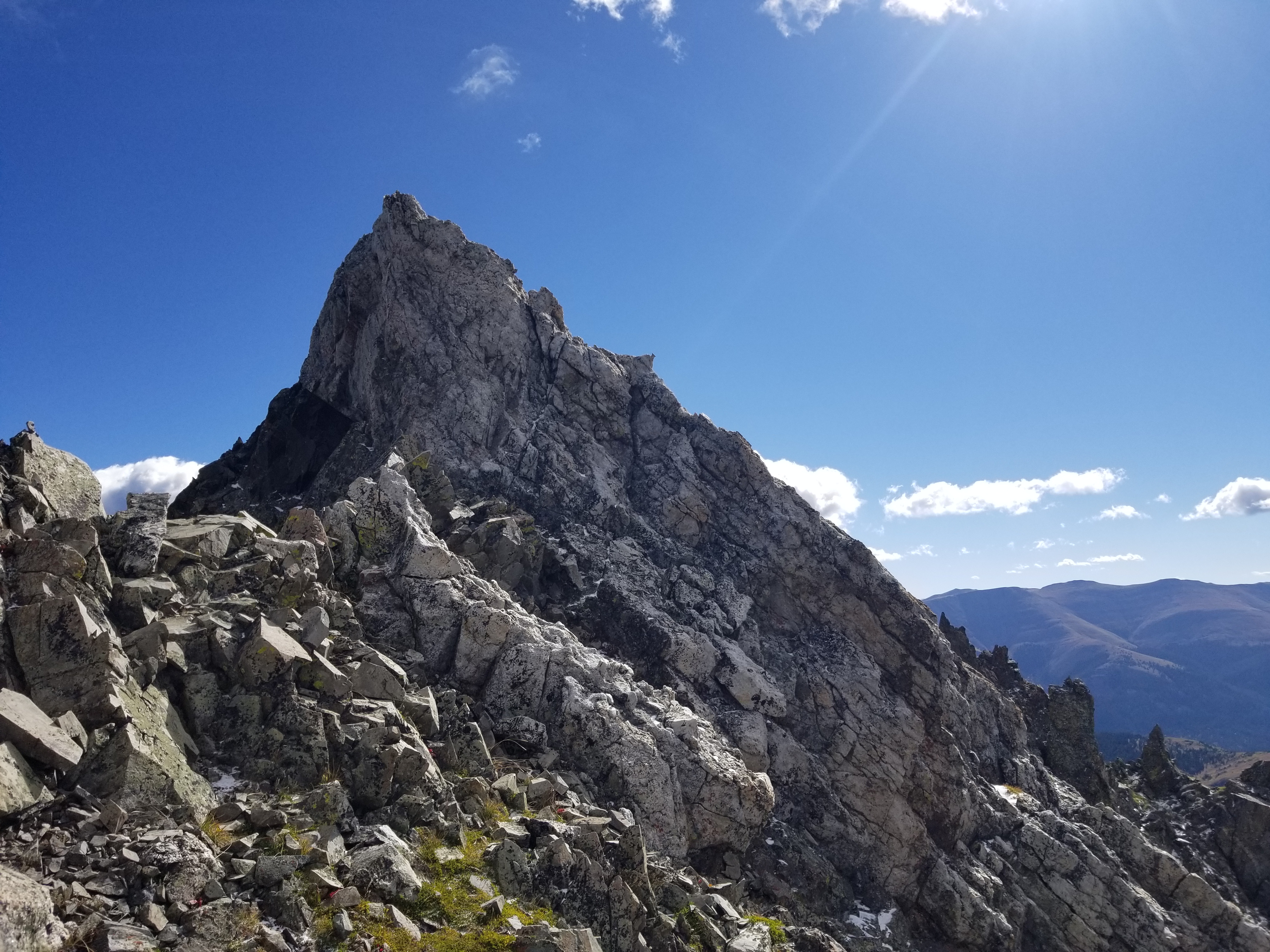
| Early on the Helen-Father Dyer ridge |
Moving very carefully with the wind, we actually made good progress on the first half mile of the ridge to Father Dyer. The scrambling wasn't overwhelming. That is until we hit a major obstacle at about 0.6 miles from Helen. It was a catwalk section leading into a fairly exposed class 3 climb. After debating it a minute my brother went forward to scout it out. He got to the top of this tower and saw that the downclimb was equally if not more exposed on the other side. While he seemed somewhat hesitant, I was almost entirely hesitant at the moves before us. I enjoy me some good scrambling but I tend to like exposure to be very minimal. We debated things a few minutes and then made the call to do a quick backtrack and bypass this obstacle on the south side of the ridge. I could see that if we dropped about 150 feet off the ridge crest we would have a pretty good traversing route forward. We didn't like having to bail around this difficulty but it was simply the right move for us. Its a good lesson in the mountains, you need to do you, period.
 |
The class 3 crux that we ultimately bypassed. The short catwalk is between my brother and myself.
This tower peaks about 20 feet above my brother's position.
The downclimb on the other side quite exposed. |
 |
| Climbing back to the ridge after our bypass, fun, easy class 3 scrambling |
 |
| Some of the easier ridge scrambling |
 |
Looking back, a difficult almost class 4 downclimb but the exposure was rather low.
This was one of the final remaining difficulties on the ridge |
 |
| Looking ahead to the remaining climb to Father Dyer |
When we regained the ridge we found better success working through the remaining difficulties. The last 0.3 of a mile of the ridge seemed to ease up and we finally found ourselves on Father Dyer's summit. As we finished that 400 foot climb to the summit we found ourselves repeating the moniker that would stick for the day: "nothing is going to come easy out here."
 |
| From Father Dyer's summit to Crystal |
 |
| From Father Dyer's summit to the Mohawk Lakes basin |
360 Photo from atop the summit of Father Dyer Peak
The only thing that came remotely easy on this day was the ridge to Crystal. It was the shortest of the connecting ridges in both distance and elevation gain. We had already hit all the class 3 coming to Father Dyer and the ridge to Crystal was just some light scrambling and ridge running. The final summit push was basically a big pile of rocks and we picked our way up through it. What greeted us on Crystal's summit was the dramatic view of Pacific. The north ridge of Pacific is a sight to see. Its tall and narrow and it snakes upward toward a pointy, notched summit area. If we didn't already know that this route was supposed to be class 2 the whole way up I would have second guessed our move going forward.
 |
| From Crystal's summit looking ahead to Pacific Peak |
360 Photo from atop the summit of Crystal Peak
The descent off Crystal was easy talus hopping. The question that loomed was a hump on the ridge just before the low saddle that starts Pacific. We didn't know what its far side would look like. We made a traverse along the side of this hump not wanting to summit it entirely. Our line was perfect for when the saddle revealed itself we had a fairly easy line to descent into it on more talus.
 |
| Mellow descending from Crystal to the hump before Pacific's ascent |
 |
| Descending the backside of the hump between Crystal and Pacific, looking at the low saddle |
 |
Ascending the upper stretches of Pacific. Lots of medium-sized rock.
You can see the that the nasty summit points of Pacific aren't quite as bad up close. |
 |
| Looking down upon Pacific Tarn from the summit of Pacific Peak |
The climb up Pacific was steep but all good class 2 rock. It was more a grunt workout than any sort of difficult scrambling. I would say the whole thing is class 2. We did come up next to some big exposure any time we would get near the ridge crest or a saddle exposed to the south. As we neared the summit area we had to wrap around to the west side before ascending up to the true summit of Pacific.
360 Photo from atop the summit of Pacific Peak
The descent from Pacific was pretty tame and predominantly just moderate rock-hopping. From the moment we had left the Wheeler Trail below Helen to here we had seen zero to no trail. Everyone what appeared like faint trail segments would come up but there was never any clear route along the way. Frankly, this was to be expected. On the route to Atlantic there is a small hump you can bypass while descending from Pacific. Conveniently there actually was a brief bit of trail leading on the west side of this hump to guide the bypass.
 |
Looking ahead to the small hump between Pacific and Atlantic.
An easy bypass trail saves you from summiting it. |
 |
| The fairly easy ascent of Atlantic Peak |
 |
| Zoomed view of Quandary Peak and the difficult points of the West Ridge |
The low point between Pacific and Atlantic was only around 13300 which meant the loss/gain wasn't too horrible between the two. We geared up for the one big final ascent of our day. With each ascent we were hitting a Gu gel and some Gatorade to fuel the energy and to add to the fun the winds were hitting us hard one more time on our way up to Atlantic. We found this ascent to be very straightforward and just an easy class 2 scramble up through medium-sized talus to gain the summit.
 |
A look at the very difficult and technical connecting ridge from Atlantic to Fletcher
|
360 Photo from atop the summit of Atlantic Peak
The descent from Atlantic was the first section of the day we repeated. We made it back down to the low saddle and then eyed a line towards the beginning of Pacific's East Ridge. The goal here was to pick a good line up and over the ridge, down towards Pacific Tarn and then towards a descent gully into the Mohawk Lakes basin. The early part worked well. We made a nice ascending traverse to the ridge and then a straight bee line down to the edge of Pacific Tarn. This alpine lake is gorgeous and it was fun walking near the shoreline as though we were on a long stroll along a beach. Using a GPX track we tried to make our way towards the proper descent chute towards the Mohawk Lakes.
 |
| Walking the edge of Pacific Tarn, quite beautiful |
 |
| The upper tundra east of the Tarn before our descent |
 |
| The nasty couloir we descended, could have used some snow. |
This is where we kinda messed up a bit. As we worked the Father Dyer-Helen ridge earlier in the day we had been eyeing across the valley our potential descent line. There was an open and very steep scree gully that seemed the best of the options. It appears just before Pacific's East Ridge gets more jagged and its north slopes almost impassable. As we picked our line towards this descent I think my GPS was off a bit from the GPX track we were following. I thought I had us correct when we started to drop into a very steep and loose couloir. We were probably 50-100 feet down into it when we realized just how bad it had become. We could see a potential route without getting cliffed out but it was so steep that we felt like we were nearly hanging on for dear life on that God-forsaken scree to not slip and slide all the way down the mountain. We said never again on this route. We wondered how this could be one of the "standard" routes on Pacific. As I looked back on the maps afterwards I realized our error and how we really should have went all the way to the somewhat wider scree gully. I'm sure it was also fairly steep but hopefully it would have been more passable. You live, you learn.
Once we made it down the slope from Pacific's East Ridge the Mohawk Lakes basin trail was fairly easy to find. We hoped it would be smooth sailing all the way out. Not quite. The trail itself in the upper basin is absolutely beautiful as it meanders around some of the high lakes. What surprised us was that in several places as you begin to enter treeline the trail became difficult to follow. It seems as though there are a great number of spur trails that easily mislead. We found ourselves offtrack a couple of times having to bushwhack back to the main trail. At other times we had followed obvious trail for a quarter mile only to realize we were off the main trail when we would regain it.
 |
| One of the upper lakes |
 |
| Mohawk Lakes basin |
 |
| Mohawk Lakes basin |
 |
| Mohawk Lakes basin |
We did run into quite a number of dayhikers the further we descended. The area is quite beautiful and we can see why it is rather popular in the Breckenridge area. Once we made it back out to the 4WD road it was just a long hike back to our car. The descent took us quite a bit longer than we had anticipated and for the day we just missed making it 13 miles. A long day but an enjoyable one. The wind and the light snow on the Father Dyer ridge nearly turned us back but we are definitely glad we pressed onward, safely of course, and had a wonderfully successful day.
Splits:
2WD Spruce Creek TH to Helen Start 30:34
To Helen Summit ~ 1:27:4
To Father Dyer Summit ~ 2:17:15
To Crystal Summit ~ 41:36
To Pacific Summit ~ 1:14:35
To Atlantic Summit ~ 58:12
Track:
I have a track and waypoints from the activity all contained in the embedded Google Map. Check it out and use at your own risk.


.jpg)


No comments:
Post a Comment